Weather Data
Weather is the most important single factor influencing variation in forage production. When properly recorded, weather data are an essential part of both short-term monitoring and long-term interpretation. General observations on growing conditions and any applicable measured weather data must be considered when making changes in grazing use. Monitoring plans should include gathering information on weather (temperature and precipitation) and growing conditions (soil moisture). Recording and preserving weather observations should be a routine activity for ranchers (Clements and McLain 2015) and land managers. Weather records can be maintained in physical form as well as by electronic means. Ranch weather stations can be extremely useful for interpreting pasture-specific monitoring information. Weather patterns can vary between widely spaced agency-operated weather monitoring stations that are generally used to make drought and other environmental condition determinations for very large areas.
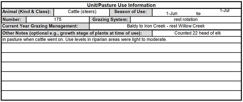 Figure 21. Actual use records are extremely valuable for interpreting why progress was made toward objectives or not.
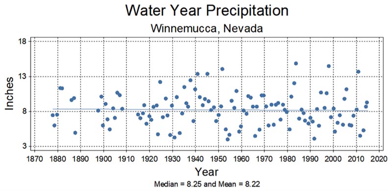 Figure 22. Weather data, like other data, show natural variability and precipitation is the most important influence on plant growth.
The Western Regional Climate Center provides weather data for many locations in Nevada at http://www.wrcc.dri.edu/summary/climsmnv.html. The Great Basin Climate and Weather dashboard is at http://gbdash.dri.edu/. The National Weather Service’s Community Collaborative Rain, Hail, and Snow Network (CoCoRaHS) is a platform conveniently available to all https://www.cocorahs.org/. The precipitation-oriented information in CoCoRaHS combined with temperature records can provide important weather and extreme event information useful in understanding changes on rangelands.
Other sources are the FS and BLM remote area weather stations (RAWS), other agencies such as the Nevada Department of Transportation, and any ranchers or others who maintain records. Relationships between seasonal precipitation patterns and temperatures can be used to interpret production and vegetation dynamics and make determinations about whether a regionally declared drought is applicable to any, all or portions of allotments.
Declaring drought based solely on the USDA Drought Monitor data (which is not recommended by the National Drought Mitigation Center) misses the ecological principle that shallow-rooted plants, such as grasses, depend on soil moisture. Soil moisture depends on precipitation that came in the months immediately before and during the effective growing season, not in the years and months prior to that. Aboveground biomass production of herbaceous species is strongly affected by the amount and periodicity of precipitation that occurs during the thermal growing season. The crop year (Sept. 1-June 30), water year (starting Oct. 1) or spring (April + May + June) precipitation can all serve as more accurate predictors of plant growth or forage production (Sneva and Hyder 1962; Mosley 2001; Mosley 2015). These have been utilized successfully (Daubenmire 1956; Sneva and Hyder 1962), and take into account the effective growing season conditions.
Insects, Disease, Wild Herbivores, etc.
Monitoring records should also include notes on the location of significant occurrences and impacts other than livestock. All rangeland vegetation is subject to disease, insect and rodent impacts. Most ranges also provide forage for other ungulates, rabbits, etc. Notes or records can augment other short-term studies to help interpret long-term studies following such impacts.
Use Mapping
Mapping of areas for proportions of the annual production that has been consumed or trampled by animals is one of the most important tools in grazing management for short-term monitoring. Use mapping can help determine locations to establish key areas, identify distribution problems and solutions, develop objectives and grazing plans, locate range improvements, and make adjustments in management plans. The utilization map for an allotment or pasture can help range managers determine whether or not the grazing plan is functioning as designed. The map can identify and indicate the relative extent of areas underused, overused and properly used. Problem areas (over and under use) are more likely in large pastures with many plant communities over a rough topography. They can be identified with a use map for closer study to determine causal factors and potential solutions. Photographs and/or Global Positioning System (GPS) points at specific use areas may be taken to display observed or measured utilization levels at certain locations. However, utilization records that are based on a limited number of utilization transects cannot be used to create a use-pattern map and provide almost no useful information about livestock distribution.
Developing utilization maps is a joint responsibility of rangeland managers and livestock operators and is essential for adaptive management. Use mapping helps managers become and stay familiar with the allotment. Comparing periodic use maps help identify chronic patterns and patterns that vary among years in response to weather, season of use and other management factors. This helps identify where adjustments may be needed in a grazing plan. Adjustments might be in the form of new or relocated water developments, fences or salt/supplement grounds, or changing the intensity of grazing by modifying the season or length of use period or the stocking rate. It may also be appropriate to complete more than one use map per year for an area if there are different species using the same area at different times of the year (e.g. wild horse winter use and spring livestock use). An approach to use mapping is discussed in Appendix J (Use Mapping, Key Species Method, and Proper Use) and in Utilization Studies and Residual Measurements (BLM 1999b).
Utilization
Utilization is the estimation of the proportion of annual production consumed or trampled by animals. The proper time to measure utilization depends on the purpose for which the data will be used. Seasonal use is useful for recording or using triggers. It may be estimated during the growing season at the end of grazing to understand physiological effects that vary by plant phenology. End-of-season utilization is estimated at the end of the grazing and growing season. Most studies on forage utilization are based on end-of-season utilization levels, especially where the focus was on stocking rate or the duration of use was season-long. Both types of utilization measurements help with adaptive management. To help observers, utilizations cages are sometimes used to show that year’s growth of plants protected from grazing. To be effective, the cages must be placed where the plants to be protected and unprotected plants that will be evaluated for their utilization are similar before placing the cage. They must be of the same species, size and health (similar in appearance), and they must have the same soil (landform, slope, aspect, elevation, etc.). For utilization cages to remain useful, they must be moved every year, preferably immediately before the grazing period. If left in one place, they show accumulating effects from protection, thatch, attracted rodent activity or bird droppings, and altered microclimate (snow drifts, etc.). These effects can increase or decrease caged plant growth and make them useless for evaluating utilization of uncaged plants.
The Key Species Method (formerly the Modified Key Forage Plant Method) has been widely recommended (Nevada Range Studies Task Group 1984) and used to monitor utilization on upland key areas. See Appendix J — Use Mapping, Key Species Method, and Proper Use for a description of this method. Utilization may be more effective than stubble height for tall bunchgrass rangelands because of the uneven use by grazers. The key is to choose methods that best measure effects of management to understand application of strategies for objectives. Note that utilization and residual vegetation are management tools for plant health, fuels management or watershed protection, not long-term resource objectives.
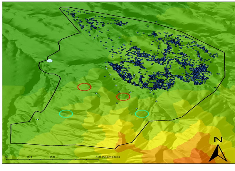
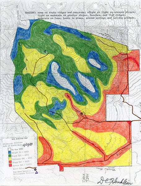 Figure 23. Ungulates select favorite places to graze,
 and understanding distribution is fundamental to recognizing opportunities or needs
 for management to address issues before they create lasting degradation.
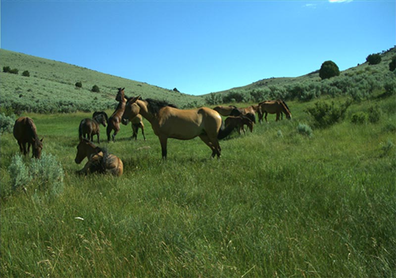
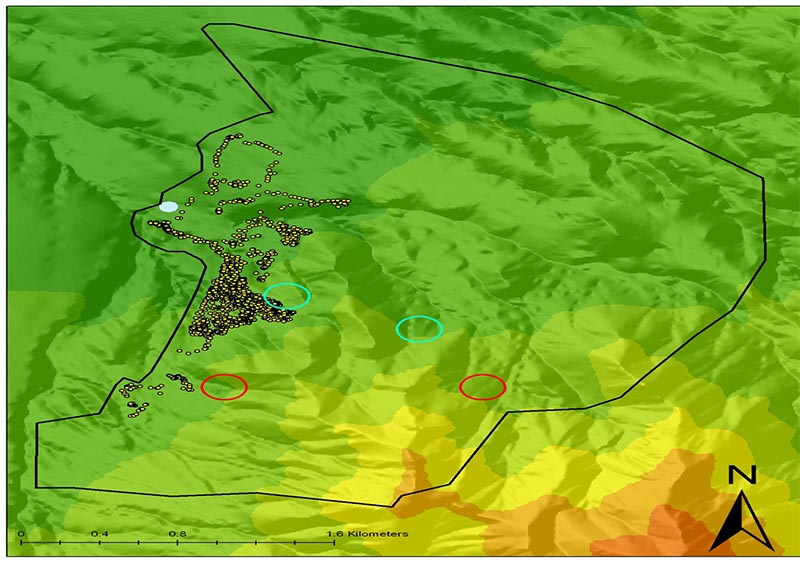 Figure 24. No herding/no supplement,
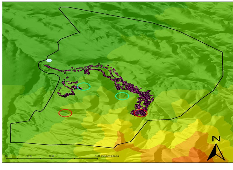 herding to supplement site 1,
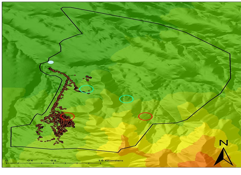 herding to supplement site 4,
 with wet year and ephemeral springs (Howery et al. 2010).
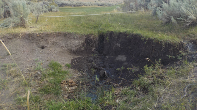
Residual Dry Matter
It is easier to see the amount remaining than to estimate the portion removed. Residual dry matter, or the amount of dead plant material and litter remaining after grazing, has been used effectively to help managers achieve soil and vegetation objectives on California annual grasslands and for rangeland areas supporting annual grasses and forbs (Bartolome et al. 2002; Guenther and Hayes 2008). Litter, or residual dry matter is a factor in soil protection and the reproduction of annual grasses such as cheatgrass (Evans and Young 1972; Trowbridge et al. 2013) and hence in the management of this fine fuel (Schmelzer et al. 2014; Monitoring Fuel Breaks sidebar). For guidance on measuring residual dry matter, see Guenther and Hayes (2008).
Stubble Height
Stubble height has been used to monitor the remaining parts of herbaceous plants after grazing, usually on meadows or greenlines. Perennial herbaceous stubble can provide greenline roughness that slows water and encourages sediment deposition and retention. Stubble height is often used as an indicator of the effects of riparian grazing management. Intensity of use versus leaf area for ongoing photosynthesis during the growing season has important implications for plant physiological responses to grazing and regrowth. Therefore, seasonal use (measured within the growing season) is often used as a trigger for livestock movement. For guidance on measuring stubble height, see Perryman et al. (2006), BLM (1999b), and Burton et al. (2011). The proper use of stubble height is discussed in Clary and Leininger (2000), University of Idaho Stubble Height Review Team (2004), Hall and Bryant (1995), and Appendix J — Use Mapping, Key Species Method, and Proper Use.
Woody Species Use
The utilization level on woody plants is often estimated as the proportion of available leaders that have been browsed. Excessive use of woody species can prevent regeneration and limit density, height, canopy volume, or habitat quantity and quality. Specific use levels on woody species are often used as triggers for livestock movement. However, observing when cattle shift their grazing from herbaceous to woody species may provide a more timely indicator of the need to move livestock where shrub density is low. Use levels for woody species should not be used as a long-term resource objective. A method for monitoring the use of woody species is addressed in Utilization Studies and Residual Measurements (BLM 1999b), and modifications of that technique for riparian areas are addressed in Burton et al. (2011) and the Ranchers’ Monitoring Guide (Perryman et al. 2006).
Streambank Alteration
Streambank alteration is often measured as the percent of the line at the edge of the streambank that has been broken or deformed, although there are a number of different methods that have specific rules, and the methods produce different results. In addition to the effects of grazing and browsing of vegetation, large herbivore and recreation use can cause physical disturbance to stream systems. Similar to stubble height, streambank alteration is an annual or short-term indicator of the effect of impacts on long-term stream condition. When streambanks are excessively trampled or altered, stream function is impaired. Excessive streambank alteration may result in decreased streambank stability, increased erosion, channel widening, decreased water storage capacity of the streambank, a decrease in deeper rooted hydrophilic (water-loving) plant species and an increase in more shallow-rooted upland plants, and a degradation of water quality and aquatic habitat (Bengeyfield 2006). Streambank alteration can be used as a tool to assess impacts, e.g. large herbivores and recreation, and to determine when these impacts may be excessive. It may be used during the grazing season to trigger a need to move livestock out of the pasture. It can also be used to help determine cause-and-effect relationships between livestock grazing and stream-riparian conditions and whether livestock grazing management changes may be needed the following year (Burton et al. 2011).
Short-term annual indicators such as streambank alteration are useful. However, it is inappropriate to use single indicators to manage streams. Managers should use a suite of indicators to assess impacts, as streams respond differently among sites. The University of Idaho Stubble Height Report (2004) suggested that it is inappropriate to use short-term indicators (e.g. streambank alteration and stubble height) as the metrics for whether or not long-term objectives are being met. Long-term resource condition data are needed to determine whether or not objectives (e.g. streambank stability or greenline stability rating) are being met. Short-term indicators are metrics for how well strategies are followed, but only if the metrics are aligned with chosen strategies. Long- and short-term data can also be used to evaluate if the strategies or indicators are useful.
Monitoring Fuel Breaks
The creation of fuel breaks can employ a variety of strategies for altering the amount, moisture content, height and continuity of both herbaceous and woody fuels (The Rangeland Fire Task Force 2015) (Trowbridge et al. 2013; Schmelzer et al. 2014; Bates and Davies 2015; Davies et al. 2015a; Davies et al. 2015b). Fuel breaks may be distinct and obvious, such as a mowed or chained strip, or they may be more diffusely located (e.g., an area of targeted, intensive grazing) (Strand et al. 2014).
As with the management of all rangelands, the methodology used to monitor fuel breaks must be able to inform whether or not the implemented strategies are meeting objectives. Short-term monitoring tracks and records the implementation of maintenance treatments and their annual effects on plant community (fuel break) attributes. For example, measuring residual aboveground biomass and fuel height can determine if fuel reduction targets were achieved. Long-term monitoring addresses changes in vegetation composition, that in turn provides insight into resistance, resilience and wildfire risk. Long-term monitoring can also identify known instances where strategies have been effective in reducing or halting fire spread, or the burning conditions that allowed a fire to cross a fuel break. Tracking efficacy (and fire conditions) can inform managers about future strategies regarding such things as break width, fuel removal, species composition, resistance to flammable species and other fuel break characteristics.
 Figure 25. Cover of USDI-BLM (1999b).
Several factors influence how a stream is impacted by alteration and how it will recover from physical disturbance. Stream gradient, streambed material composition, streambank soil composition, vegetation cover and type, channel geometry, and flow rate and timing all influence how a stream responds to alteration (Burton et al. 2011; Dickard et al. 2015). These site-specific factors need to be taken into consideration when determining appropriate levels of annual alteration for a particular stream. Stabilizing vegetation, rock armoring or embedded large wood provide streambank stability. Streambanks lacking needed vegetation cover generally are those most affected by streambank alteration. In these cases, management should be designed to promote an increase of stabilizing plant species, and bank alteration may not be an effective measure of chosen strategies to effect this outcome.
When streambank alteration is being used as an annual indicator for livestock grazing impacts it is measured annually after grazing. When other large herbivores or recreationists are contributing to streambank alteration, it is appropriate to measure streambank alteration before and after livestock use to help understand the causative factor. It is most effective if measured as soon as possible after livestock have been moved from the area so that alteration by livestock can easily be distinguished from natural disturbances by wild ungulates (Burton et al. 2011), and because precipitation events and/or high flows can “wash out” livestock alterations and make them less visible. Although the alteration may not be visible after a precipitation or high-flow event, the effect of trampling and/or destabilizing the bank still exists until riparian recovery exceeds bank alteration.
As with all monitoring techniques, in order for data to be valid and useful, practitioners must be adequately trained to collect streambank alteration data. Burton et al. (2011) provide guidance for monitoring streambank alteration and other indicators. Other methods will produce different results.
Section Summary
All of the aforementioned short-term monitoring tools are used to indicate effects from the management applied in that year. These data address conformance with the grazing plan. To adjust management, consider all the grazing management tools, season, duration, rotation, and intensity of use to meet objectives. Adjustments in stocking rate alone seldom resolve grazing management issues. Short-term monitoring data should not ordinarily be used as long-term goals or objectives. However, residual or total vegetation height or cover may be a guide for management in specific seasons for specific situations tied to objectives.
