Key Areas
Rangeland managers, livestock operators and others who know the range should cooperatively select key areas based on issues, opportunities and goals. Once selected, key area baseline data becomes the foundation for a site-specific objective. (See Appendix B — Ecological Sites and the Handbook section “Stratifying Landscapes for Analysis and Monitoring”). They should serve as representative samples for long- and/or short-term monitoring (e.g., range conditions, trends, seasonal degrees of use, resource production, etc.). Key areas are used where random sampling locations would be prohibitively expensive for accurately (Appendix I — Statistical Considerations) monitoring grazing in most pastures or allotments (Appendix F — Scales in Monitoring). Key areas for long-term, effectiveness monitoring should also be used for short-term, implementation monitoring.
- Consult standards and guidelines, land use and activity plan goals and objectives. Use a vegetation map, aerial photo, soil survey, ecological site inventory and whatever other useful information is available for the allotment. Use these to determine soils, ecological sites, disturbance response groups, ecological status, and/or state and risk of transition, if possible. Map vegetation types in the allotment or pasture, if possible. Key management areas should be located where the ecological situation is well understood. They should not bridge two or more ecological sites. Soil components must be confirmed in the field because soil inclusions lead to differing potentials within the same soil map unit (e.g., sandy surface textures produce more perennial grass than finer soil surface textures). The attributes of the objectives(s) monitored must be present on the area selected.
- Refine objectives for each key area at the time they are set up in the field based on baseline data and potential to reach objectives. Consider the management plan, including primary management strategies (and possibly triggers and end-of-season indicators).
- Overlay use pattern map, water locations (noting timing of water availability), and vegetation map together on a base map. Look for the most productive soils and sites with the highest use. Heavy or moderate use areas targeted for improvement in the plan and that are no farther than a mile from water are good places to put a key area. Avoid areas of concentrated use (such as near a water trough) and areas of slight to light use (such as steep slopes). These do not provide much information unless they are used to compare trend or production between heavy– or moderate-use areas and slight-use areas. A key area should represent an area that provides a significant amount, but not necessarily the greatest amount, of available forage in the pasture. This can be ascertained from an evaluation of the ecological site and utilization maps, together with an on-site assessment.
- Choose area(s) representative of the use area. Two or more key areas may be needed for large pastures, pastures that have very rough topography or widely spaced water, various areas where animals tend to locate, areas where different kinds of animals graze, where the pasture is grazed at different seasons, or where multiple seasonal wildlife habitats are important.
- The key area must have the potential to improve or decline in response to planned management. There must be sufficient plants of the key species (those plants identified in objectives) that an increase is predicted from the management plan and enough that they could decline if management does not achieve objectives, work or get implemented correctly. Within an ecological site, the area between abundant and sparse vegetation of the key species is often the best place to establish studies.
- Do not establish a key area in a small or atypical location, or close to fences or other infrastructure. Avoid water sources, trails, corrals, historic salt grounds, bedding grounds, dusting areas, shade and other concentration areas. And, stay away from roadsides or other disturbances.
- Where multiple herbivore (wild and domestic) use is significant, select key areas as needed.
- Confine monitoring studies on a key area within the boundary of a single soil, single land form, and single plant community and ecological site. The Study Site Location Form included in this appendix (Page 92) is an example for recording the location and specific selection criteria.
- Consider the season(s) of use and class of animal because diet preferences change by season and by kind and class of animal.
- Establish new key area(s) and discontinue reading old key areas if they do not address objectives. This can happen when the pattern of grazing use is significantly modified because of a difference in season(s) of use, kinds or classes of grazing animals, pasture size, watering locations, or other factors affecting grazing distribution or the management plan.
Critical Management Areas
Critical management areas must be treated with special consideration because of inherent site factors, size, location, conditions, values or significant potential conflicts among uses. It may be important to designate and monitor critical areas as key areas because they have a significant resource value or concern. However, critical areas may not be extensive in area and do not reflect the management of the entire grazing unit. Critical management areas may include:
- Critical wildlife habitat,
- Areas of species of concern or special status species,
- Highly erodible areas,
- Isolated aspen patches, or
- Riparian areas.
Designated Monitoring Areas
In riparian zones, areas selected for short- and long-term monitoring may be called designated monitoring areas (DMAs) (Burton et al. 2011). In riparian areas, representative designated monitoring areas should:
- Represent management concerns within the riparian area as reflected by riparian PFC assessments, management plans, resource values and especially objectives (e.g., a functional-at-risk reach associated with spawning areas for listed fish, if spawning habitat is targeted by recovery plans).
- Have the potential to respond to the planned management. For example, a recent gully or recently incised stream is not suitable because it no longer has much opportunity for vegetation to influence channel stability and riparian functions. This will eventually return as the channel widens and develops the area needed for a new floodplain and riparian vegetation inside the gully. Functional-at-risk reaches are often a higher priority for management and monitoring than are nonfunctional or properly functioning reaches.
- Have species present that will respond to management and meet objectives.
- Represent similar reaches in use and response, if there are similar reaches in the unit. They should not be located on isolated atypical areas, such as where trails enter or cross a riparian area, water gaps or inaccessible locations surrounded by willow thickets.
- Be characterized by existing stream survey or PFC assessment locations where available (if they meet the above criteria) because of the existence of historic photos and data. Other historic photo sites may also be suitable, if they meet the criteria.
 Figure 15. Riparian areas that provide habitat for listed species,
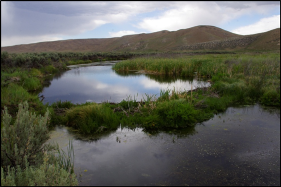 such as Lahontan cutthroat trout, may be considered critical areas.
Key Species
Key species should represent objectives and be a significant component of the potential desired plant community. For example, in a riparian area, key species are normally riparian stabilizers adapted for the soil redox conditions (often sedges or bulrushes on fine soils and willows or aspen on rocky soils or steeper gradients). The species selected should:
- Be those that respond to management. Species selected remain consistent until or unless objectives change.
- Key forage species should be palatable to the grazing animals during the planned season of use and respond to grazing management. Very palatable plants that have low production potential should not be selected as key forage species. Species with low palatability or lower palatability than other abundant species should not be selected. Very palatable or very unpalatable species give a falsely high or low use reading, leading to under- or over-use of the important more or less palatable forage species.
- Key species should be perennial except on annual rangelands, and be selected after:
- Choosing the key area and evaluating the present plant community.
- Deciding the plant community or important plant(s) that will reflect the objectives.
- Giving due consideration to planned management, such as kinds and classes of grazing animals and season of use.
- Thoroughly evaluating the factors affecting grazing distribution. If only one kind of animal grazes the pastures, a single plant species generally may suffice as the key species in plant communities with low diversity.
Study Site Location Form
Download the Study Site Location Form (fillable PDF)
Swanson, S., Schultz, B., Novak-Echenique, P., Dyer, K., McCuin, G., Linebaugh, J., Perryman, P., Tueller, P., Jenkins, R., Scherrer, B., Vogel, T., Voth, D., Freese, M., Shane, R., McGowan, K.
2018,
Nevada Rangeland Monitoring Handbook (3rd) || Appendix H - Procedures for Selecting Key Areas and Key Species,
Extension | University of Nevada, Reno, SP-18-03
