State and Transition Models
State and transition models (STMs) are a component of the ecological site description, and are developed to describe changes in soils, vegetation dynamics and management interactions. These models provide a method to organize and communicate complex information about vegetation response to disturbances (fire, lack of fire, drought, insects, disease, etc.) and management. A STM describes alternative states, range of variability within states, processes and mechanisms that cause plant community changes (pathways) within states, maintenance of a current state, transitions between states, and restoration toward a previous state. A STM diagram provides a general graphical overview and the accompanying narrative describes the states and transitions in detail.
A state is a recognizable complex of the soil resource and associated vegetation occurring within a characteristic climate. Phases within a state describe different plant communities with characteristics that cycle, or vary, back and forth through time, or in response to natural disturbances, management or weather. Ecological processes connect the soil and vegetation within a state to sustain a "dynamic equilibrium" within a specified range in variation for plant species composition (or the set of associated phases). Primary ecological processes for an ecological site include the reproduction of important plant species, energy and nutrient cycling; and the capture, storage, plant uptake and timely release of water from precipitation.
Resilience and resistance concepts describe the stability of a state and the various phases within a state. “Resistance is defined as the ability of the system to remain the same while external conditions change, whereas resilience is the ability of the system to recover after it has been disturbed” (Stringham et al. 2003). A resilient state can vary widely following disturbance and then return to the equilibrium condition. Resilient plant communities require only adjustments to management, if any, before the functioning of ecological processes returns the system to equilibrium following a disturbance.
Transitions are directions, or trajectories, of vegetation and soil change that result in an altered functioning of one or more of a state’s primary ecological processes. Pathways reflect phase changes within a state. Transitional pathways reflect changes within a state that are only reversible if they do not exceed the resistance or resilience thresholds between states. A transition can be triggered by natural events and/or management actions (or inaction). Some transitions may occur very quickly and others over a long period. Two aspects of a transition are recognized: reversible and irreversible. Prior to crossing a threshold, a transition is reversible and represents an opportunity to reverse or arrest the change. Conventional management practices are used to reverse the transition. Once a threshold is crossed, however, the transition is irreversible without significant inputs of management, dollars and energy.
States are relatively stable and resistant to change caused by disturbances up to a threshold point. A threshold is the boundary between two states, and when crossed, results in one or more of the primary ecological attributes or processes having been irreversibly altered. Irreversible implies that restoration cannot be accomplished through natural events or a simple change in management. Active restoration (brush management, range planting, prescribed burning, etc.) must be accomplished in order to return to a previous state. Once a threshold is crossed, disequilibrium among one or more of the primary ecological processes exists and will be expressed through changes in the vegetative community and eventually the soil resource. A new stable state is formed when the resultant chaos ends and the system establishes a new equilibrium among the primary ecological processes.
Transition across a threshold to a new state often represents a change in resource values, such as wildlife habitat, livestock forage, watershed functions and/or soil protection. Some transitions and new states also reflect an increase in wildfire hazard, increased risk of spreading invasive weed seeds, or an increased risk of accelerated soil loss.
Each state reflects a different set of management possibilities and management methods. The vegetation within each state changes with the seral stages in plant succession (or phases) recognized for the state. The role of managers is to manage ecological processes to facilitate change along desired pathways and to prevent transitions to less desirable states. Within each state, certain management strategies facilitate community resilience or resistance and maintain desired plant communities.
In general, preventing a desired plant community from transitioning across a threshold is much less expensive than returning a site that has crossed a threshold. Restoring ecological processes and returning a site it to its original state often requires drastic actions that are expensive and risky. However, some potential states provide better products and services than the current state, and people invest much time and money in restoration, attempting to reverse an undesired transition. The top priority for large land areas is to implement management actions that maintain a landscape’s (multiple plant communities) resilience, so less of it crosses a threshold, becoming less productive with fewer management options. This strategy is especially true for areas where a change in management could address the responsible stress or stresses and reverse a transition before it is too late.
References and Products
Ecological sites represent a continuing endeavor to collect and categorize knowledge about the nature of native plant communities. A state and transition model can be used to describe vegetation dynamics and management interactions associated with each ecological site. Ecological site descriptions and state and transition models help evaluate management, guide further study, and provide for proper use opportunities. More than 1,000 different ecological sites have been described in Nevada.
Disturbance response groups (Stringham et al. 2016) are groups of ecological sites that respond to management similarly and have the same basic structure to their state and transition models. Among their ecological sites, response rates and the amount of vegetation required to achieve resilience may differ, although the management outcomes are similar. Similarities in response allow managers to apply some concepts across broader areas.
Ecological site descriptions for each major land resource area in Nevada are available from the Ecological Site Information System online at: https://esis.sc.egov.usda.gov/Welcome/pgESDWelcome.aspx . Detail soil series descriptions are available from the NRCS Soils website at: http://www.nrcs.usda.gov/wps/portal/nrcs/site/soils/home/. The Web Soil Survey can be used to generate soil maps, ecological sites and associated information and is available at: http://websoilsurvey.sc.egov.usda.gov/App/HomePage.htm.
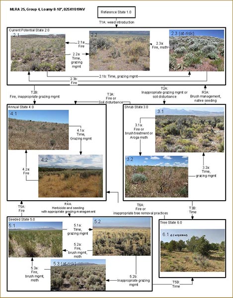 Figure 46. Each of the boxes in the state and transition model represent observed conditions, phases within a state. The arrows represent drivers of change and indicate the need or opportunity for management.
Key MLRA 25 Group 4 Loamy 8-10" 025XY019NV
Reference State 1.0 Community Phase Pathways
- 1.1a: Low-severity fire creates grass/sagebrush mosaic; high-severity fire significantly reduces sagebrush cover and leads to early/mid-seral community, dominated by grasses and forbs.
- 1.1b: Time and lack of disturbance such as fire or drought. Excessive herbivory may also decrease perennial understory.
- 1.2a: Time and lack of disturbance allows for shrub regeneration.
- 1.3a: Low-severity fire or Aroga moth infestation resulting in a mosaic pattern.
- 1.3b: High severity fire or Aroga moth significantly reduces sagebrush cover leading to early/mid-seral community.
Transition T1A: Introduction of non-native species.
Current Potential State 2.0 Community Phase Pathways
- 2.1a: Low-severity fire creates grass/sagebrush mosaic; high-severity fire significantly reduces sagebrush cover and leads to early/mid-seral community dominated by grasses and forbs; non-native annual species present.
- 2.1b: Time & lack of disturbance such as fire or drought. Inappropriate grazing management may also reduce perennial understory.
- 2.2a: Time and lack of disturbance allows for regeneration of sagebrush.
- 2.3a: Low-severity fire or Aroga moth infestation creates sagebrush/grass mosaic. Brush treatment with minimal soil disturbance; late-fall/winter grazing causing mechanical damage to sagebrush.
- 2.3b: High-severity fire or Aroga moth significantly reduces sagebrush cover leading to a early/mid-seral community.
Transition T2A: Inappropriate grazing management favoring shrub dominance and reducing perennial bunchgrasses will lead to phase 3.1. Soil-disturbing treatments (such as tilling or intensive brush management) will lead to phase 3.2.
Transition T2B: Catastrophic fire (to 4.1); inappropriate grazing management that removes bunchgrasses, favors shrubs and promotes the presence of non-native annual species (to 4.2).
Shrub State 3.0 Community Phase Pathways
- 3.1a: Low-severity fire or Aroga moth infestation creates sagebrush/grass mosaic. Brush treatment with minimal soil disturbance; late-fall/winter grazing causing mechanical damage to sagebrush.
- 3.2a: Time and lack of disturbance.
Restoration R3A: Brush management and seeding of native deep-rooted bunchgrasses (probability of success is low).
Restoration R3B: Brush management and seeding of crested wheatgrass and/or other non-native desirable species.
Transition T3A: Fire and/or soil-disturbing brush-removal treatments.
Transition T3B: (If site has neighboring trees) Time and lack of disturbance such as fire favors an increase in tree dominance (from phase 3.1).
Annual State 4.0 Community Phase Pathways
- 4.1a: Time and lack of disturbance. Big sagebrush is unlikely to reestablish and may take many years.
- 4.2a: High-severity fire.
Restoration R4A: Application of herbicide and seeding of desired species (probability of success best immediately following fire).
Seeded State 5.0: (Seeded wheatgrass species are the dominant grass). Community Phase Pathways
- 5.1a: Time without disturbance.
- 5.2a: Fire, brush management or Aroga moth infestation reduces shrub component.
- 5.2b: Inappropriate grazing management decreases perennial bunchgrass understory.
- 5.3a: Fire, brush management or Aroga moth infestation.
Transition T5A: Catastrophic fire (coming from 5.3).
Transition T5B: (If site has neighboring trees) Time and lack of disturbance allows trees to dominate site resources.
Tree State 6.0 Community Phase Pathways
- 6.1a: Time without disturbance.
Transition T6A: Catastrophic fire that kills trees. Inappropriate tree removal practices may also lead to dominance by non-native annuals.
