Riparian Areas - Riparian areas act as a transition to adjacent uplands from streams and other waters. Riparian areas protect the aquatic resource, and provide unique habitats for wildlife, livestock and people. Properly functioning riparian areas (Prichard et al. 1993, 1994, 1998, and 2003, Dickard et al. 2015) keep water on the land longer, improve water quality, produce important fish and wildlife habitats, produce lush green vegetation, and retain their beauty for recreation and stability during recurring flow events (five to 25 year recurrence interval). Everyone benefits when riparian areas function properly. As a natural attractant for wildlife, livestock and human uses, riparian areas are often used in ways that detract from their ability to function properly. Functional-at-risk riparian areas have one or more attributes that make them susceptible to degradation. Nonfunctional riparian areas fail to dissipate stream or wave energy, fail to enhance infiltration and recharge aquifers, and fail to capture sediment. Rather, they become sources of sediment creating water quality problems, with excessively high dirty water flows after precipitation or snowmelt events and excessively low flows and warm water in summer. Whereas proper functioning condition riparian areas withstand most floods and droughts (Appendix C - Weather Variability), they often improve through these events. However, some very large infrequent floods (e.g. 100 year events) may cause some properly functioning riparian areas to degrade and become nonfunctional or functional-at-risk.
Classification of riparian areas is less complete than upland ecological sites. However, some larger meadows or other homogenous vegetation types and soils relationships have been documented (Manning and Padgett 1995; Weixelman et al. 1996 and 1999), and some ecological site descriptions with state and transition models are available for Utah and California. A draft NRCS manual on the development of ecological site descriptions for lotic systems is in development (Stringham and Repp 2010). The FS uses scorecards to provide condition ratings for various rangeland types (e.g., Weixelman et al. 1996 and 1999). Various stream surveys have been used throughout Nevada (e.g., FS 1985; Elko BLM 2002). They combine estimations with measurements and have been used to help set management goals and objectives, and track progress. Stream classification (e.g. Rosgen 1996) has also been used to make management interpretations and will inform riparian ecological site descriptions. These and other classification tools can assist in the assessment of riparian proper functioning condition (PFC) in relation to site potential for each stream reach or lentic area.
The assessment for lotic or lentic riparian PFC (Prichard 1993, 1994, 1998, and 2003; Dickard et al. 2015) or Stream Visual Assessment Protocol II (NRCS 2004) helps identify impaired functions or values that managers could address to promote riparian restoration through management. Dickard et al. (2015) and Swanson (2016) describe a seven-step process for integrated riparian management that is very parallel to adaptive management (Appendix D - Adaptive Management) and the framework for monitoring above. Focusing on the at-risk areas and negative attributes identified in PFC assessment helps identify management priorities to set objectives. Objectives for riparian areas could focus on species composition of riparian meadows (Weixelman et al. 1996 and 1999), on the streambank (Winward 2000; Burton et al. 2011), or on structural features of vegetation that drive channel form and stability (Winward 2000; Burton et al. 2011). Objectives for lentic riparian areas could similarly focus on risks to function, such as erosion, deposition, adequacy and composition of vegetation, etc., as well as values-based objectives, such as forb diversity for sage-grouse brood rearing habitat. Objectives address factors that are directly influenced by management activities, including livestock grazing, roads, upland watershed vegetation treatments, water storage and use, or others.
Understanding how similar streams or wetland areas have responded to or changed with specific management helps managers prescribe management and set objectives. Because the physical characteristics of riparian areas change when they become nonfunctional, such as through channel incision, the original potential may no longer be viable as an objective, at least for the timeframe of the management plan. However, stream channels as well as lentic riparian areas go through predictable sequences of change in response to management and hydrologic events (see sequence of events in Setting Objectives Appendix E - Characteristics of Good Objectives).
 Figure 4. Cover of Dickard et al. (2015).
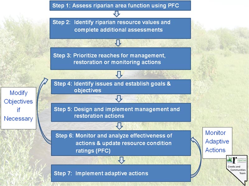 Figure 5. Integrated Riparian Management after Dickard et al. 2015.
Understanding how similar streams or wetland areas have responded to or changed with specific management helps managers prescribe management and set objectives. Because the physical characteristics of riparian areas change when they become nonfunctional, such as through channel incision, the original potential may no longer be viable as an objective, at least for the timeframe of the management plan. However, stream channels as well as lentic riparian areas go through predictable sequences of change in response to management and hydrologic events (see sequence of events in Setting Objectives Appendix E - Characteristics of Good Objectives).
To help set objectives, managers can interpret the indicators of functionality and predict the sequence of events that must happen for functionality to return (or for it to restore specific riparian values). This sequence of landform, vegetation and hydrology adjustments defines management and monitoring needs and methods. Because riparian areas managed to retain proper functioning condition often continue to improve, the cyclic process of setting objectives, managing and monitoring often spirals a riparian area into a condition that provides the optimum in resource values. Riparian monitoring often focuses on a common set of short-term and long-term indicators, such as the Multiple Indicators Method (MIM) of Burton et al. (2011). Objectives should be adjusted to account for spatial variation and changes in conditions and values. This cyclic process helps identify the mechanics of restoration and the variety of tools for management. Because changes in recovering riparian areas are sometimes obvious, photographs have often been quite useful for documenting change.
Inventory and Assessment of Base Resources - Inventory and assessment are different from monitoring. The data collected and information developed in inventories and assessments are important components of the management picture. Often inventories supply site-specific baseline data points. Modern assessment methods such as riparian PFC (Prichard et al. 1998 and 2003; Dickard et al. 2015) and interpreting indicators of rangeland health (Pellant et al. 2005), evaluate the current status of a number of indicators that address basic system functionality. The Assessment, Inventory, and Monitoring (AIM) Strategy (See Appendix F - Scales in Monitoring) provides data on the status, condition, trend, amount, location and spatial pattern of vegetation, soil and water resources. AIM relies on standard core indicator metrics, also useful to assess rangeland health (Pellant et al. 2005) from thousands of plots annually located to statistically sample the diversity of BLM lands. These data are also used in the Habitat Assessment Framework (Stiver et al. 2015).
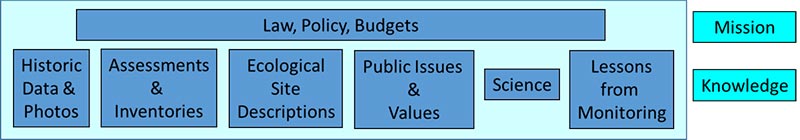 Figure 6. A variety of kinds of information informs agency priorities for rangeland management.
Evaluating several indicators allows the manager to more precisely identify problems and their causes. This helps develop priorities, objectives and strategies for management actions designed to fix specific problems, rather than having to try to address the whole system without focus. Although not trend monitoring, when inventories and assessments are repeated through time, they may help identify changes in issues, opportunities and priorities. Burton et al. (2011) provide quantitative methods for measuring riparian trend, just as Herrick et al. (2005a and b) provide methods for measuring indicators of rangeland health. Such data help identify issues, states and transitions; set objectives; determine limitations; and select key areas. The FS has developed a protocol for collecting riparian vegetation and channel data from wadeable stream locations (Merritt et al. 2017) and another for inventorying groundwater-dependent ecosystems (USDA-FS 2012). A largely BLM effort is underway to develop a quantitative inventory and monitoring protocol for lentic areas (Dickard et al. 2018 DRAFT).
Most Nevada BLM offices have Ecological Site Inventory (ESI) and/or Soil Vegetation Inventory Method (SVIM) inventories. The FS too has collected soils and plant community type data that may remain in their files. These data sets are the best historical vegetation data available for some areas and could be useful for tracking long-term changes in some landscape-scale or site-specific objectives. Many areas have existing monitoring data from established key areas and various forms of data, such as photos in reports and files within agency and ranch or other files. These can shed light on baseline conditions for trend, old issues that may have been resolved, or ongoing foci for improving management. Summarizing existing data is useful for context in setting objectives.
Broad-scale assessments or inventories and historic data about specific locations can be interpreted through the lens of classifications or combined with other resource inventories to make interpretations more valid or specific. For example, vegetation data are much more interpretable with the benefit of a soil survey, and stream survey data makes more sense with systematic stream classification and/or proper functioning condition assessment. A series of publications sponsored by the Western Association of Fish and Wildlife Agencies focuses on sagebrush ecosystem resilience and resistance (Chambers et al. 2014 and 2017) to suggest priorities and management tools across large land areas. Research on sage-grouse by many Department of Interior agencies and personnel is summarized by Hanser et al. (2018). Concepts from these publications could be refined through application of ecological site descriptions. And, ecological site descriptions and other science- based knowledge is continually updated with new science.
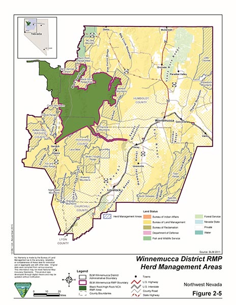 Figure 7. Land use plans as illustrated by this map of herd management areas from the Winnemucca District BLM Resource Management Plan (2015) provide broad direction for rangeland management.
 Figure 8. Cover of Pellant et al. (2009).
 Figure 9. Cover of the Nevada Sagebrush Ecosystem Program Conservation Credit System Manual.
Land Use Planning - Large Scale - As required by law, both the FS and BLM develop land use plans that at a broad scale allocate resources and set goals and objectives. These plans set the stage for more site-specific planning efforts by describing appropriate uses; desired conditions; and management goals, objectives or strategies. The BLM develops Resource Management Plans (RMPs), which are periodically updated or amended (e.g. Sage-grouse Final Environmental Impact Statement Record of Decision(USDI-BLM/USDA-FS 2015)). The FS similarly uses Land and Resource Management Plans (Forest Plans). Since these land use plans are of varying ages, include geographically diverse areas, and are completed by two different federal agencies, they contain a range of objectives, flexibility and specificity. Land use plans also include monitoring plans with requirements that vary from general to specific.
Because more than 70 percent of the land in Nevada is managed by the BLM or FS, and most of these lands are used for livestock grazing and other uses, the source of agency objectives is important. Land use plan objectives become or lead to objectives for management of individual grazing allotments. The relationship of these land use plan objectives to monitoring is that land use plans, agency activity plans, agency standards, and the Standards for Rangeland Health can directly provide (if and where appropriate), or can inform, objectives applicable to individual allotments and specific areas.
To implement the Fundamentals of Rangeland Health (43 Code of Federal Regulations (CFR) 4180.2(b)), standards and guidelines for livestock grazing and wild horse management have been developed by BLM Resource Advisory Councils. According to BLM's regulations, management of the public lands must be designed to make progress toward and achieve these standards (43 CFR 4180.2(c)). Revised resource management planning proceeds under guidance in the Land Use Planning Handbook (H-1601-1). Recent Resource management plans and amendments incorporate the applicable Resource Advisory Council standards, and specific actions for sage-grouse, vegetation and fuels management, drought, etc.
FS standards and guidelines were developed for both the Humboldt and Toiyabe National Forests (now combined into the Humboldt-Toiyabe National Forest) in forest plans written in the mid-1980s and amended several times. These forest plan standards and guidelines include direction specifically for management of livestock, such as forage utilization and streambank disturbance levels. More recent thinking (e.g. Wyman et al. 2006; Swanson et al. 2015) suggests these tools should be used for short-term monitoring only where they effectively address the strategy used for success at the local level, and then they should be set within the context of that local management. Perhaps this will be reflected in future forest plan revisions.
Activity-level plans are often specific to one or two types of activities in smaller areas. Activity-level plan types include allotment management plans for livestock grazing, herd management area plans or wild horse territory plans for wild horses and burros, and habitat management plans for wildlife or fisheries. Activity plans usually address: 1) an issue or specific use, 2) existing and desired resource conditions, 3) objectives addressing these conditions, 4) standards or guidelines to direct management of the activity, and 5) a monitoring plan established to determine whether the activity is meeting objectives and achieving or moving toward the objectives. In Nevada, the BLM multiple use decisions or grazing permit renewal environmental assessments are often used as surrogates for allotment management plans. Often the process of developing plans is collaborative, using processes of or like Coordinated Resource Management (Phillippi and Cleary 1993). Currently, not all livestock grazing allotments on either the FS or BLM have an allotment management plan (or surrogate); therefore, management of these allotments is guided by the objectives and standards in the higher level land use plans. There are many advantages of developing a plan through Coordinated Resource Management, for all parties concerned.
On private rangeland, planning is at the discretion of the landowner. However, others such as NRCS, Conservation Districts, University of Nevada Cooperative Extension, Nevada Departments of Agriculture and Wildlife and Division of Forestry, Sagebrush Ecosystem Technical Team, U.S. Fish and Wildlife Service, and others may help with information, technical assistance, financial assistance, mitigation funding or conservation credits, and/or collaboration. Publications such as the National Range and Pasture Handbook (NRCS 2003) help with planning. The conservation benefits of NRCS rangeland practices were assessed by Briske (2011; Briske et al. 2016). The Nevada Conservation Credit System (CCS) is a market-based opportunity in the Nevada Sage Grouse Conservation Plan (Nevada Sagebrush Ecosystem Technical Team 2014), and is an important mechanism for avoidance, minimization and mitigation of impacts from anthropogenic disturbances, such as roads, mines and powerlines. The best private and public land management plans are developed in collaboration with landowners, managers, scientists, and other knowledgeable and interested parties. When a use occurs on both public and private lands, it makes sense to plan and monitor across ownerships.
Activity Plans Address
- An issue or specific use.
- Existing and desired resource conditions.
- Objectives addressing these conditions.
- Strategies to guide management of the activity.
- A monitoring plan established to determine whether the activity uses selected strategies and is achieving or moving toward objectives.
