Floodplain Protection Inventory for the Carson River
What is a floodplain?
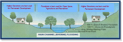
The floodplain of a river is the adjacent low-lying land that temporarily stores floodwater. This riverine floodplain is an integral part of a river. In most cases, the soil on floodplains was deposited by the river or creek over an extended period of time. After heavy rains, including winter rain-on-snow storms, high water spills over the riverbanks and spreads out across the floodplain. This is the way rivers and streams naturally work. See Figure 1.
Figure 1. The floodplain along valley bottom rivers is the low-lying land next to the channel that temporarily stores floodwater from large winter rain-on-snow storm events.
Since 1998, the Carson Water Subconservancy District has supported a citizen’s watershed management and planning group called the Carson River Coalition. The Coalition has addressed issues of water quality, water supply, floodplain management and wildlife habitat together, in an integrated fashion. In 2003, the majority of Coalition members determined that protection of natural floodplains is the most important goal of the Coalition, and its main message.
The District and the Coalition completed the Carson River Watershed Regional Floodplain Management Plan in 2008. This plan has been adopted by the governments of all five counties through which the river passes.
The suggested actions of the Management Plan urge river communities to “Protect the natural functions and benefits of floodplain lands” and to “Retain lands that provide floodplain storage and maintain or restore connection of the river with its floodplain through land acquisition, conservation easements, local open space programs…and other protection methods.” This special publication provides details and illustrations showing how much of the Carson River’s floodplain has been protected from urban and residential development as of 2015.
Why should we protect floodplains?
Many floodplains nationwide are now urbanized and as a result have sustained costly damage to homes, businesses and infrastructure during flood events. In some communities, rivers are lined with engineered levees in an attempt to protect urban and residential neighborhoods. The building of costly levees, dams and floodwalls to hold back floodwaters is referred to as “structural flood control.” After the devastating Mississippi River floods of 1993, the Army Corps of Engineers, which had designed many flood control structures, increasingly recommended nonstructural floodplain management (Galloway, 1994). This method relies on keeping floodplains open and undeveloped. Simply put, keeping homes and businesses out of harm’s way is now recognized as the best and most cost-effective way to prevent flood damage and deaths. In addition to being less costly than building flood levees, nonstructural floodplain management provides many other benefits. Open floodplains support diverse streamside (riparian) vegetation which in turn filters water, removes pollutants, and provides valuable bird and wildlife habitat. A natural floodplain allows floodwater to infiltrate into the soil and recharge groundwater aquifers. The sponge-like capacity of soils allows them to store water and slowly release it into the channel at a later time.
Jeffrey Mount, author of California Rivers and Streams, writes about the choice that communities need to make between the structural and nonstructural approaches to managing for floods. He calls the structural approach “serial engineering,” because each time a flood damages levees, they are repaired and built stronger. This makes people feel safer and encourages even more urban development of the floodplain. After each large flood, this cycle is repeated. In many cases, as in Los Angeles, the river is finally put into an extremely expensive concrete-lined channel. After that happens, the fish, wildlife and water quality values are lost. For rivers like the Carson, which still has open floodplains, the best and least costly way to reduce flood hazards and prevent the loss of these values is to protect the floodplains from urban and residential development in the first place. Agricultural fields, pastures and parks are much better uses for our floodplains.
How did we define the floodplain?
The authors sought input from the floodplain managers of Lyon County, Carson City and Douglas County in order to define the floodplains along the river itself (riverine floodplains). Churchill County was not included in this study because most floodplains there are below the Lahontan Reservoir and exhibit different kinds of flood hazards. Alpine County in California and areas of alluvial fan flooding were also beyond the scope of this inventory. The authors chose to define the floodplain as the Federal Emergency Management Agency’s (FEMA) “one-percent-chance” flood zone, which has a one-in-100 chance of flooding in any given year, combined with the boundaries of the area actually flooded in January 1997, as mapped in the Nevada Bureau of Mines and Geology’s Flood Extent Map (Rigby, et.al. 1998). These two areas are similar in size and shape. The FEMA one-percent-chance flood zone is also known as the 100-year flood zone or Zone A, and it defines zones of risk called Special Flood Hazard Areas. Since the FEMA flood zone is to some degree hypothetical, we added the areas that flooded in the large (80+-year) 1997 Flood as a way of ensuring a conservative picture of lands known to be at relatively high risk of flooding. This combined floodplain is shown in blue (unprotected) and green (protected) on the maps in Figures 2 and 3. The figures show riverine floodplains only—not alluvial fan floodplains.
Defining and mapping protected flood zones
For the purpose of this inventory, “protected floodplain” refers to land that is either publically owned or privately owned and not likely to be developed. Briefly, “protected” parcels include:
- Publically owned open space and parks — by federal, state, county, city, or general improvement district agencies
- Privately owned lands — with a conservation easement and/or development restrictions (including those small parcels in Douglas County’s Transfer of Development Rights Program)
- Privately owned open space — by homeowner associations (common areas)
How much of the river’s floodplain have we protected so far?
For this publication, representatives of local governments and nongovernment organizations were asked to forward legal descriptions of protected floodplain lands to a GIS mapmaker. These protected parcels of land are shown within the riverine floodplain as green polygons. We tallied the total number of acres of floodplain lands protected from development in each county. The results of this inventory are illustrated in the maps (Figures 2, 3) and in Table 1. The total area of the combined riverine floodplains amounts to 39,879 acres within Douglas County, Carson City and Lyon County. Within this floodplain area, 31 percent have been identified as protected and 69 percent as unprotected. Specific acreages and percentages for each county are shown in Table 1.
Many strategies are used for floodplain protection
Most county floodplain managers, county staff and county commissions now recognize the importance of protecting floodplains from urban development. Programs such as the transfer of development rights have been implemented in Douglas County (Douglas County Master Plan, 2011). Nonprofit organizations such as The Nature Conservancy are working with ranchers to purchase conservation easements, which allow the owner to continue ranching, but prevent current or future owners from developing floodplain lands for urban or residential lots. In Carson City, voters approved a Quality of Life Initiative authorizing an increase in the sales tax that provides funding for an Open Space Program. Since 2000, the Open Space Program has acquired and protected hundreds of acres in the floodplain. According to a representative from The Nature Conservancy, there are currently several agricultural property owners in the Carson Valley willing to sell conservation easements on their ranch lands. In the post-recession economy of the early 21st century, it has been difficult to raise public funds to take advantage of these conservation opportunities.
Carson City has a combination of river valley floodplain along the Carson River and alluvial fan floodplains coming down from the mountains and hills surrounding the town. The Carson City Open Space Program has purchased much of the FEMA flood zone near the river. The historic areas in the downtown and some residential areas on the edges of town experience alluvial fan flooding rather than riverine flooding. In the alluvial fan neighborhoods, the City has employed structural floodplain measures, such as excavating large detention basins at the foot of Combs, Vicee and other canyons. Because flood pathways on developed alluvial fans are less predictable than riverine flood pathways, these flood control structures provide more protection than areas of open space. Some areas to the south and west of the state Capitol complex that flooded in 1997 may still be at risk from future floods. The City plans to excavate additional flood detention basins upstream of these sections of town. Future acquisitions and possible sites for flood detention basins include properties at the top of the alluvial fans of Ash and Kings Canyon Creeks. As alluvial fans elsewhere in the Carson River Watershed are developed, local officials may want to examine the structural approaches being used by Carson City.
Figure 2. Map of protected and unprotected riverine floodplain lands within Lyon County in the Carson River Watershed as of 2015. (Alluvial fan and small tributary floodplains are not shown or included in this publication.)
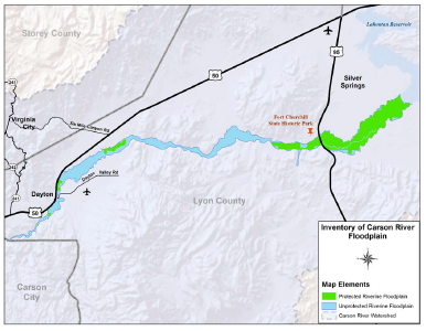
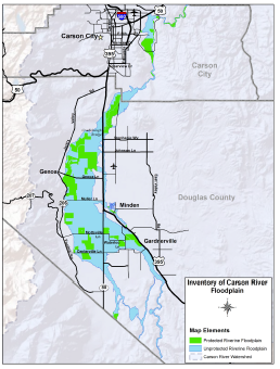
Figure 3. Map of protected and unprotected riverine floodplain lands within Douglas County and Carson City in the Carson River Watershed as of 2015. (Alluvial fan and small tributary floodplains are not shown or included in this publication.)
The Carson River in Lyon County has protected floodplain near Dayton. Further downstream, the State Park at Fort Churchill extends down to Lake Lahontan, protecting considerable floodplain lands. Because FEMA includes “open water” in its definition for Special Flood Hazard Areas, the entire acreage of Lake Lahontan is technically a “protected flood zone.” It is all owned by the U.S. Bureau of Reclamation, and encroachment (development) in the reservoir is not and has never been possible. For the purpose of addressing floodplains that are at risk from development, the limit of the inventory in Lyon County has been set at the mouth of Lake Lahontan.
What could change?
Defining the riverine floodplain for this publication is a moving target in some respects. FEMA Flood zone and Floodway boundaries will be updated and changed in the near future. The 1997 Flood Extent Maps from the Nevada Bureau of Mines and Geology will not change.
Study collaborators were not in complete agreement with what constitutes “protected land,” and it is apparent that some gray area exists. Some contributors to this inventory suggested that areas of the floodplains designated by FEMA as “floodways” should be regarded as “protected” land. Floodway lands are subject to extra regulations that require expensive mitigation measures if they are developed. However, since floodway lands may be developed, they were not considered “protected” for the purpose of this publication.
Finally, it is possible that some parcels of protected land were not accounted for in this analysis. Thus, this inventory is a rough depiction of protected lands. It is designed to be used primarily as a baseline map for measuring the community’s progress toward floodplain protection goals over time.
The choice is ours
The local governments and the people of the Carson River watershed face a stark choice. Fortunately, most of the riverine floodplains in the watershed are still free from urban development and retain their natural floodplain functions. Communities need to know that if they protect floodplains from urbanization, they will not just be protecting homes, businesses and infrastructure. They will also enable the river’s ecosystem to remain vibrant, with increasing biodiversity in its wetlands, riparian zones and aquatic communities. Protecting floodplains is an essential step in restoring and maintaining the river’s water quality and wildlife habitat.
On the other hand, if floodplain lands are gradually developed for subdivisions, resorts and ranchettes, the eventual result could be a river confined to an expensive concrete-lined flood channel with little beauty or ecological value. It is up to the current residents to decide which future they want for the river. Protecting floodplains usually takes private donations or public funds in the form of a bond initiative or other mechanism in order to compensate private property owners for the economic value of their development rights. Approving such a measure takes considerable public support and political will.
This inventory provides a benchmark or baseline of the location and percentage of protected floodplain land within Douglas County, Carson City and Lyon County. The same analysis can be conducted again in the future to track progress toward protecting riverine floodplains. In the meantime, these data can be used to refine floodplain protection goals. How much more floodplain land should be protected and over what period of time? Are all these lands equally important to protect, or should floodway and other high-risk lands close to the channel be considered higher priority? In essence, this inventory can be used to refine the broad objectives outlined in the Carson River Watershed Regional Floodplain Management Plan.
Acknowledgments
The following individuals contributed time and resources to the preparation of this publication. Considerable time and GIS support were provided by Eric Schmidt, GIS Supervisor, Douglas County. County floodplain managers and engineers Mimi Moss, Erik Nilssen, Karin Peternel, Mitch Blum, Robb Fellows and Rob Loveberg assisted in framing the study and defining protected lands and the riverine floodplain. Ann Bollinger, Dominique Etchegoyhen, Jacques Etchegoyhen, Duane Petite and Rich Wilkinson collected and delivered protected parcel information to Douglas County GIS. Brenda Hunt and Ed James of the Carson Water Subconservancy District reviewed and printed the publication.
References
Carson Water Subconservancy District. (2008). Carson River Watershed Regional Floodplain Management Plan, Carson Water
Cobourn, J. & Lewis, S.R. (2011). Agriculture is a good fit in floodplains. University of Nevada Cooperative Extension, Fact Sheet 11-69. Agriculture is a Good Fit in Floodplains
Cobourn, J. & Lewis, S. R. (2012). The importance of Carson River floodplain lands to our communities. University of Nevada Cooperative Extension, Fact Sheet 12-06. The Importance of Floodplain Lands to our Communities
Douglas County Master Plan. (2011) Volume II, Chapter 6, Growth Management, Douglas County
Galloway, G.E. (1994). Sharing the challenge: Floodplain management into the 21st century, The Flood
Lewis, S.R. & Cobourn, J. (2004). River corridor protection: Carson River Coalition’s main message, University of Nevada Cooperative Extension Fact Sheet 04-71. River Corridor Protection: Carson River Coalition’s Main Message
Mount, J.F. (1995). California Rivers and Streams: The Conflict Between Fluvial Process and Land Use. University of California Press. Berkeley, CA.
Rigby, J.G., et. al. (1998). The 1997 New Year’s Floods in Western Nevada. Special Publication 23, Nevada Bureau of Mines and Geology, Reno, NV.
Published by:
Cobourn, J. and Lewis, S., 2015, Floodplain Protection Inventory for the Carson River, Extension | University of Nevada, Reno, Fact Sheet FS-15-05
An EEO/AA Institution. Copyright © 2026, University of Nevada Cooperative Extension.
A partnership of Nevada counties; University of Nevada, Reno; and the U.S. Department of Agriculture
