River Corridor Protection: Carson River Coalition’s Main Message
Introduction
The Carson River Coalition (CRC) conducted a survey of its members in 2003 to determine “What is the one, most important message the public needs to understand about our watershed?” The CRC is an open group of volunteers and agency representatives from all six counties in the Carson Watershed. More than 50 members, including resource managers, educators, agriculturalists, county commissioners and scientists offered message ideas. These ideas were ranked in a second survey. Once the messages were prioritized, one received a much higher rating than the rest, as most important for the public to understand. This message is:
“Protect the floodplain from future development. Once the floodplain and especially the river’s meander belt corridor are impacted by development, the river loses the ability to reestablish its natural functions. Agricultural fields near the channel are critical for floodwater attenuation, ground water recharge, non-point source pollution buffering and providing habitat for wildlife.”
Preserving open, undeveloped land adjacent to the river channel is the highest priority. When natural rivers flow through flat valley bottoms like the Carson and Dayton valleys, they establish a dynamic equilibrium that requires the channel to meander and change its course over time. If we put homes or infrastructure near river channels that naturally meander, we create hazards for lives and property, because such development can be severely damaged when rivers change course during major flood events.
The Carson River is already highly unstable
Over the last 150 years, the river has actually dug itself deeper into the valley floor. The channel bottom is about 6-10 feet lower than it was when the valley was settled in the 1850’s.
Technically, the Carson River channel is “incised” or “down cut” in many places, especially on the valley floors. The river channel has responded in this way because of the cumulative effects of logging, mining, urbanization, agriculture, channel straightening and road building over time. One major problem with this river incision is that floodwaters from major storms are mostly confined in the channel instead of overflowing the banks as they did before the channel was incised. The river is in a gully that will widen over time as floodwaters rip away its unvegetated vertical banks. Through a well-researched natural process known as “channel evolution,” (Schumm et al., 1984) incised rivers widen their gullies radically, until there is room for a new meandering channel with its own floodplain at a new lower level.
Why is the land near an incised channel a dangerous place for development? Because the floodwaters of an incised river are trapped within a gully, the high velocity flood flows are concentrated rather than being dispersed over a floodplain. The deep confined flows have more power than shallow dispersed flows, and the result can often be severe bank erosion.
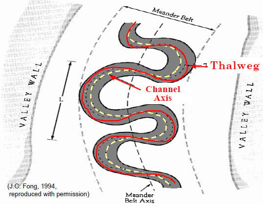
Incised rivers are known to widen their gullies, and valley bottom rivers tend to meander. During floods, the river will erode the outer banks of bends, and these bends will also migrate downstream. The area at greatest risk for development can be estimated by studying the landforms and soils on the valley floor. Careful channel measurements and analysis of the amount of sediment being transported are other important inputs. Scientists also search for clues about the extent of river meandering that occurred before European- American settlers arrived. Often, analysis of aerial photographs helps reveal the extent and width of past river meander bends or belts. If it meandered over a half mile-wide corridor in the past, there is a possibility that it can do so again.
Floodplain managers throughout the nation are urging local jurisdictions to consider the risks of allowing urban and residential development near meandering channels. On the other hand, keeping such areas in agricultural or other open space uses is ideal in terms of avoiding economic losses for property owners and the community as a whole.
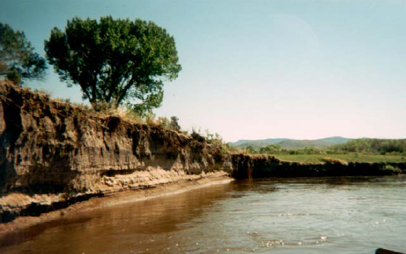
Steep, unvegeted riverbanks are a sign of channel instability.
Are flood control projects the answer?
In some communities, where floodplains have been developed, expensive flood control projects have been built with public tax money after lives have been lost and property destroyed. Unfortunately, such projects, which often rely on hardened riverbanks, flood levees next to the channel, or concrete channels, do not always work. For example, levees may break, flooding large areas thought to be “safe” for development. Such projects also transfer the damaging effects of concentrated flow to communities downstream.
These communities often experience floods that are much bigger than ever before, because there is not as much floodplain space upstream to hold or slow down floodwaters as there was before hardened riverbanks or levees were built.
Some communities allow structures to be built on floodplains near river channels as long as the building pad level is raised high enough. This is sometimes accomplished by using “fill” to elevate the finished grade, so it is possible to put the first floor of the building above the elevation of what the Federal Emergency Management Agency regards as a 100-year flood (roughly, the largest flood expected in 100 years). This too can be an unsafe practice. Such structures are still at risk from high velocity flood flows that can erode the filled soil under their foundation. These structures also decrease the amount of low-lying floodplain that can store water in very large flood events, again making flooding worse elsewhere in the valley and downstream.
River expert Jeff Mount (1995) notes that if urbanization can be kept away from channels, costly flood control projects may be avoided in the future. If future developments ever require protection from floodwaters relatively low-cost “set-back levees” could be constructed at or near the outer margins of the protected meander belt corridor. When levees are placed away from rivers, channels have room to migrate and develop riffles, pools, and riparian vegetation. Moving levees away from rivers has the added attraction of allowing rivers to store discharge on their floodplains, thereby reducing upstream and downstream flooding impacts.
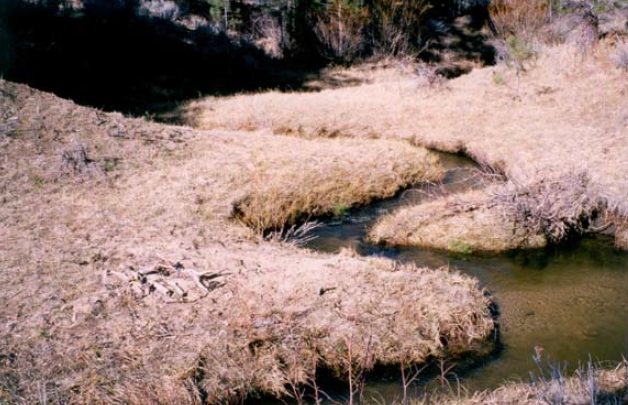
This creek has established a new meandering channel in the bottom of its incised gully.
How can we protect floodplains from future development?
The members of the CRC have rated “protect the river’s meander belt corridor from future development” as the most important message for the public and all pertinent jurisdictions to heed. Land use planners emphasize that it is much less costly to prevent development in hazardous areas than it is for the community to try to protect development after it is built.
Much of the land currently bordering the Carson River in valley bottoms is ranch land. The best long-term uses for these lands are agriculture, parkland or other open space. There are several ways to keep development out of the meander belt corridors as described by presenters and participants at the Carson River Coalition’s Carson River Conference in 2004.
- Purchase of development rights and the creation of conservation easements. Private ownership is maintained and development potential is purchased. This allows for maintaining native vegetation and agricultural lands. Funding may be sought from a variety of sources such as public grant programs, conservancy organizations, and others non-profits. In exchange for tax benefits, landowners may also consider voluntarily retiring development rights.
- Compensate landowners for maintaining floodplain. This is similar to the approach above but allows the landowner to maintain development rights plus be compensated for keeping the land open and unobstructed.
- Acquisition. Land near channels may be purchased and managed by a public entity.
- Collaborative regional planning. Regional planning that involves all stakeholders in the watershed and considers cumulative effects of development. Regional plans should be implemented and enforced by local authority.
- Zoning and regulations. Develop and strengthen state statutes and local ordinances to restrict river corridor development. Create incentives for land developers to cluster structures away from the channel. This can increase property values if all residents in the subdivision have recreational access to the undeveloped land along the river channel.
- Education and outreach. Conduct education campaigns that inform citizens and community decision-makers of the environmental, esthetic, and economic benefits associated with restricting development in the river corridor.
- Multiple approaches. Many believe the answer to river corridor protection does not lie in one approach but rather a combination of ideas mentioned above and other innovations.
Single channel rivers on valley floors will reestablish meanders even if they are straightened or their channels are incised into the floodplain (Mount 1995).
References
- Association of State Floodplain Managers. 2004. No Adverse Impact. ASFM.
- Horton, G. 1997. Carson River Chronology, Nevada Division of Water Planning, Carson City, NV.
- Inter-Fluve, Inc. 1997. Fluvial Geomorphic Assessment of the Carson River, Prepared for the Western Nevada Resource Conservation & Development, Inc., Carson City, NV.
- Mount, J. 1995. California Rivers and Streams, The Conflict between Fluvial Process and Land Use, University of California Press, Berkeley, CA.
- Prichard, D. 1998. Riparian Area Management, Bureau of Land Management National Applied Resource Sciences Center, Technical Reference 1737-15, Denver, CO.
- Schumm, S.A., M.D. Harvey, and C.C. Watson. 1984. Incised Channels: Morphology, Dynamics, and Control. Water Resources Publications, Littleton, CO.
Published by:
Lewis, S. and Cobourn, J., 2004, River Corridor Protection: Carson River Coalition’s Main Message, Extension | University of Nevada, Reno, FS-04-71
An EEO/AA Institution. Copyright © 2026, University of Nevada Cooperative Extension.
A partnership of Nevada counties; University of Nevada, Reno; and the U.S. Department of Agriculture
