Agriculture is a Good Fit in Floodplains
Introduction
When European Americans settled the Carson Valley in the early 1850s, they grew crops and irrigated pastures in the floodplain of the Carson River. The pioneers recognized that the Carson River floods its nearly level floodplain frequently, so they built towns and residential areas away from the channel.
Today, 160 years later, the Carson Valley community is fortunate that most of its floodplain is still occupied by farms and ranches. These farms and ranches are responsible for much of the charm of the wide open, green valley floor. The value of these open spaces goes beyond scenic resources. The floodplain plays a vital role in the safety of our community and downstream communities when large rain-on-snow floods occur, about every 15 or 20 years. In fact, the Regional Floodplain Management Plan for the Carson River Watershed recommends that communities like the Carson Valley should “protect the natural functions and benefits of floodplain lands.” It also recommends that we “retain lands that provide floodplain storage and maintain or restore connection of the river with its floodplain through [various] protection methods.”
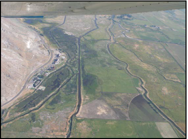
Agricultural fields in the floodplain sustain much less damage from large Carson River Floods than lands with urban or residential development. (C. Gourley)
Agricultural land use allows important floodplain functions
The formation of the floodplain on a valley floor is caused by the river. The river channel naturally meanders through the landscape and over time deposits sand, silt and other soil-forming material, especially during floods. These deposits provide fertile soil for agricultural production. In turn, the use of floodplain land for agriculture allows the land to continue to provide beneficial functions to society. The Federal Emergency Management Agency (FEMA) describes three types of “natural and beneficial functions” of floodplains that warrant protection (Carson River Coalition, 2008):
- Floodplains have an important positive impact on flooding. Flood waters can spread over a large area of flat open land. This reduces flood velocities and provides water storage to reduce flood depths downstream, reducing flood damage risks to downstream communities.
- Water quality is improved in floodplains where vegetative cover prevents soil erosion and acts as a filter for runoff and overbank flows.
- Floodplains can act as recharge areas for groundwater and provide habitat for diverse species of flora and fauna.
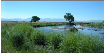
Reserving floodplains for grazing and other agricultural uses also provides vegetation and open space for bird and wildlife habitat and scenic values. (Washoe Environmental Protection Department)
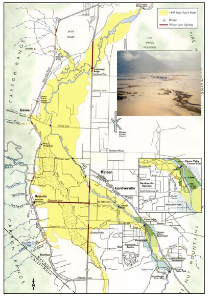
The 1997 flood (depicted in yellow) was almost entirely on Carson Valley agricultural land. This spreading of flood water reduced the flood’s intensity and depth, and prevented flood damage downstream. (Map: NV Bureau of Mines and Geology, 1998; Photo: Marilyn Newton, Reno Gazette Journal, 1997)
The map above shows the extent of the flooding in the Carson Valley in 1997. The area that was flooded stands out clearly in yellow. This land has been used for agriculture for over 100 years, and it provides our community with the three beneficial functions described previously. In addition, the scenic quality of the green open ranchland increases the appeal of the valley for business and tourism. Some ranchers in the Carson Valley have placed Conservation Easements on portions of their ranches in order to guarantee that future owners will continue to farm floodplain land rather than subdivide and develop it.
The mistake communities make
About 50 miles north of Gardnerville and Minden, the cities of Reno and Sparks have urbanized most of the floodplain of the Truckee River in the “Truckee Meadows”. The flood damages there were more than 30 times as costly as those along the Carson River during the large floods of January 1997. This is because the Carson Valley can still accommodate large over-bank flows in its agricultural floodplain lands. If Carson watershed residents allow urban development in their floodplains, future residents are likely to experience the same kinds of expensive flood damages as those in Reno and Sparks. Moreover, our neighbors to the north are currently looking at an estimated cost of over a billion dollars to fix their flooding problems (Truckee River Flood Project, 2011).
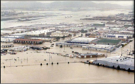
Because most ranches have been purchased and developed in the Reno area, the flood damages there in 1997 were over 30 times more costly than in the Carson Valley. (Marilyn Newton, Reno Gazette Journal)
According to the Regional Floodplain Management Plan, Carson watershed communities must promote incentives such as conservation easements to help floodplain property owners keep their lands in agricultural and other open space land uses. Otherwise there is strong possibility some of our floodplains will be lost to additional development. It will take citizen involvement and the cooperation of local and state agencies to find ways to help preserve our existing floodplains. Although current local, state and federal laws allow for development within the floodplain, the cities of Reno and Sparks have found that this can result in devastating impacts during flood events. By acting now and helping those who own these important floodplain areas, we can avoid the immense costs associated with trying to protect future developments that could be located there.
The Carson River Watershed Regional Floodplain Management Plan was developed by the Carson River Coalition’s River Corridor Working Group based on input from community members who attended public meetings. The web address for this plan is shown below.
References
- American Rivers. 2011. “The Multiple Benefits of Floodplain Easements.” AMERICA’S RIVERS.
- Carson River Coalition. 2008. “Carson River Watershed Regional Floodplain Mngt Plan.” CWSD.
- Truckee River Flood Project. 2011.”The Living River Plan—Locally Preferred Plan,” Version 2.2. The Living River.
- NV Bureau of Mines and Geology, 1998. “The 1997 New Year’s Floods in Western Nevada.” Special Publication 23.
Published by:
Cobourn J. and Lewis S., 2011, Agriculture is a Good Fit in Floodplains, Extension | University of Nevada, Reno, FS-11-69
An EEO/AA Institution. Copyright © 2026, University of Nevada Cooperative Extension.
A partnership of Nevada counties; University of Nevada, Reno; and the U.S. Department of Agriculture
