Be wary of building on riverfront property
If you own or are considering buying property near the bank of a river or stream, beware of building a home there! If the property is mapped as “Zone A” Regulatory Floodplain, that means flooding is a very real possibility — at least 1 percent chance in any year.
Flooding also causes channel migration which can threaten your home beyond water damage. Channel migration occurs when the river bank erodes, allowing the river to change its course. If your property is composed of soils and sediment laid down by the river over time, the river can easily erode away 50 or 100 feet of your property in a big flood. River channels will naturally move according to the laws of physics. Valley bottom rivers tend to meander over their immediate floodplain unless blocked by a bedrock outcrop. Meanders swing back and forth across a valley and sweep down the valley.
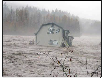
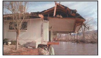
Sometimes whole houses wash away in a flood!
Most local jurisdictions have setback ordinances that state how close to perennial streams and rivers a property owner can build. These setbacks may range from 30 to 150+ feet from the channel. Douglas County has a required setback of 50 feet. Be sure to abide by the setback ordinance, and consider putting your home even farther away than the minimum required distance.
The channel of the Carson River migrated widely across the Carson Valley during the last century. The aerial photo below shows three separate channels that were active during that period, and many more can be seen that were active before settlers moved here. All of these channels moved throughout their lifetimes.
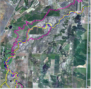
Past River Channels, Genoa to Cradlebaugh Bridge
Yellow - 2003 Carson River
Blue - 1938 Carson River
Pink - 1906 Carson River
This map shows three separate 20th century Carson River channel locations (Jean Stone and Randy Pahl, Nevada Division of Environmental Protection)
Channel migration often happens suddenly in big, rain-on-snow flood events. Climate experts predict that these kinds of floods will occur more frequently in the future. Though bank erosion is natural during floods, people who have built structures close to channels often try to stop this process by hardening the banks. This causes further problems, including increased flood hazards downstream. A better solution is to create a wide buffer strip along the riverbank that is not disturbed by development, but instead is managed to encourage growth of native plants. Such buffers can be 300+ feet wide to provide safety for homes (NEMO website).
Dangers of channel migration are severe. This home in the Dayton Valley was torn apart when banks were eroded by the force of floodwaters in the incised channel. (Marilyn Newton, Reno Gazette Journal)
Alluvial fans also harbor severe channel migration hazards
Property owners who live away from rivers on the alluvial fans at the foot of mountain ranges face less obvious flood hazards. Every alluvial fan has a stream or dry wash that emerges from the mountain canyon at the top or apex of the fan. Fans are constructed over thousands of years by flood debris that washes down the channel from the mountains. These large flood events are usually caused by intense thunderstorms. Though such floods are rare, they will recur. The mass of water that rushes from the canyon can carry enough debris to plug the old stream channel. The flood will cut a new path within the fan — another form of channel migration. Homes in the way can be severely damaged or destroyed by such high velocity floods.
Alluvial Fan floods are very different from valley bottom or river floods. Most alluvial fan floods are flash floods, occurring suddenly from a summer thunderstorm. Big river floods usually happen in winter, when a warm Pacific rainstorm dumps several inches of rain on a snow-covered range such as the Sierra.
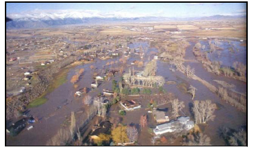
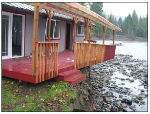
Riverfront homes in south Gardnerville flooded in 1997. (Marilyn Newton, Reno Gazette Journal)
What advice should you take?
Property owners are being advised to build away from dry washes, streams, and river channels. In the past the government often built flood dams or levees to protect neighborhoods after they were flooded. Ironically, this often led more people to build in the hazardous areas and caused more damage. Now, the Federal Emergency Management Agency (FEMA) advises people to stay out of harm’s way (Galloway, 1994). Levees are not only costly for taxpayers, they also fail in big floods. The huge flood disasters on the Mississippi River in 1993 and 2011 and in New Orleans in 2005 were aggravated by the failure of flood levees.
The Regional Floodplain Management Plan for the Carson River recommends that property owners consider personal safety, property loss, and the impacts to the river and its floodplain before building near a dry wash, stream or river channel. It urges county planners as well as private builders and developers to study and avoid the hazards of building where channel migration could occur. This is less costly and more effective than the older practice of building flood dams and levees.
Since the year 2000, several long-time ranchers have created legal protection for their low-lying floodplain land, either through sale of their land to a conservation organization or by selling a conservation easement. Such actions can ensure that residential neighborhoods are never built in harm’s way. They can also maintain open space to store flood waters, reducing the flood risks to downstream communities.
The Floodplain Management Plan was developed by the Carson River Coalition’s River Corridor Working Group, based on input from citizens who attended public meetings. The web address for this plan is shown below.
References
Carson River Coalition. 2008. “Carson River Watershed Regional Floodplain Management Plan.” CWSD.
Galloway, G. E. 1994.”Sharing the Challenge: Floodplain Management into the 21st Century.” The Flood.
University of Nevada Cooperative Extension NEMO/Riparian Buffer website link NEMO
Cobourn, J., Lewis, S., and Swanson, S.
2011,
Don’t Put Your Home and Family at Risk from Floods!,
Extension | University of Nevada, Reno, FS-11-70
