Nevada's Weather and Climate
Introduction
Weather and climate are related, but they are not the same. The difference between weather and climate is time. Practically speaking, weather determines which clothes you decide to put on today, but climate determines the type of clothes that are in your closet.
Weather and Climate Basics
Weather describes the variation of the atmosphere in a particular place over a short period of time. Weather conditions include changes in air pressure, temperature, humidity, clouds, wind and precipitation – rain, hail and snow. Weather can change over the course of minutes, hours, days or weeks.
Climate is the usual or expected weather for a particular place or region, which is typically evaluated over a 30-year time period referred to as a normal. The timescale for climate is months, seasons, years, decades, centuries and even millennia. Climate is often thought of as just the long-term average temperature and precipitation, but it also includes variability and the likelihood of extreme events. Climate is an assessment of the types of weather that are expected – or maybe not unexpected – in different seasons. Every place has its own normal climate. For example, Las Vegas typically gets thunderstorms in the summer. Much of Nevada gets winter rain or snow when large storms that form over the Pacific head eastward.
Weather and climate are influenced and defined by a number of factors, including atmospheric pressure, winds, ocean currents, temperature and topography. Atmospheric pressure (the weight of the atmosphere, also known as barometric pressure) is an important driver of weather and climate. Weather maps indicate areas of similar atmospheric pressure with lines called isobars (see Figure 1). Areas with high pressure are marked H and are typically associated with sunny weather. Areas of low pressure are marked L and are more likely to receive precipitation. At the surface, air moves from areas of higher pressure toward areas of lower pressure, producing wind. Larger differences in pressure generate stronger winds. Therefore, closer isobar lines indicate windy conditions.
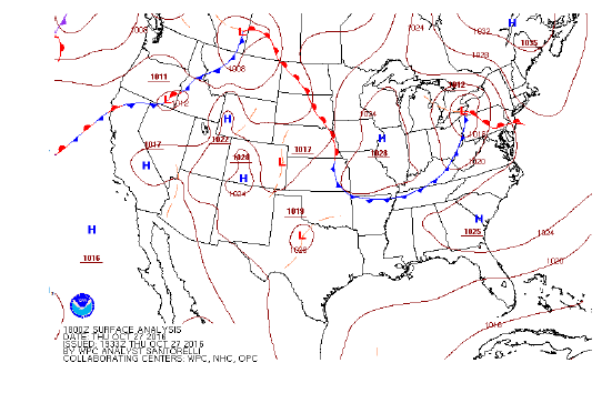
Figure 1. Surface weather analysis map for the U.S., Oct. 27, 2016. The isobars (brown lines marked with numbers) distinguish constant pressure areas. The lines with symbols depict frontal boundaries. (Source: National Weather Service (NWS) Weather Prediction Center, North American Surface Analysis.)
Fronts develop when air masses of different densities and temperatures come in contact. You may be familiar with this in the form of cold and warm fronts. Fronts, whether cold or warm, typically mean increased wind, rapid changes in temperature, and often precipitation for the local area.
Meteorology and Climatology
Meteorology is the scientific study of the atmosphere. A meteorologist describes the current weather conditions and makes short-term forecasts (typically no more than seven to 10 days). To produce forecasts, meteorologists rely on real-time observations and computer models of the atmosphere. In addition to weather station and rain gauge observations, satellite and radar technologies and weather-balloon-based measurements are used to track storm systems and air masses across the U.S.
Climatology evaluates the large-scale and long-term drivers of weather. It includes the study of past climate and projected future climate. Climatologists use a variety of instruments, technologies and observations to document aspects of past and current climates and to model past and future conditions. Climate information is immensely useful for mid-term and long-term planning and is frequently used by farmers, ranchers, the military, land and water managers, and the shipping and construction trades, among others.
Climate conditions are mapped in many different ways by numerous local, regional and national entities. For example, gardeners who utilize the United States Department of Agriculture (USDA) plant hardiness zones (see Figure 2) to select plants from a nursery are already acquainted with climate. These growing zones are based on averaging 30 years of minimum winter temperatures.
Nevada Weather and Climate
Although Nevada is the driest state in the nation, it is also a mountainous state. In the mountains, the climate tends to be colder and wetter. In fact, Nevada means “snow-capped” in Spanish, and much like other Westerners, Nevadans rely heavily on mountain snow for their water supplies (Green, 2015).
Differences in climate from one place to another reflect Nevada’s size and rugged topography, which ranges from over 13,000 feet in the White Mountains to just 500 feet above sea level at the Colorado River (Green, 2015). The fact that elevation is a particularly important driver of weather and climate is no surprise to high-country travelers familiar with the increased likelihood of high winds and wet or snowy weather on mountain passes.
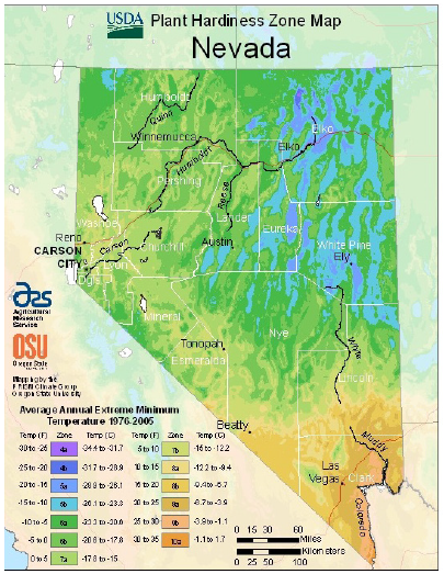
Figure 2. The U.S. Department of Agriculture (USDA) Plant Hardiness Zones are based on extreme minimum temperatures, 1976–2005. The color variation indicates the broad range of climate conditions in Nevada. (Source: USDA, Plant Hardiness Zone Map.)
Climographs provide a snapshot of “normal” weather conditions by representing average temperature and precipitation in a specific location over a 30-year time frame. Figure 3 shows climographs for Ely and Boulder City that quickly illustrate how two basic climate parameters differ in these locations. The blue lines indicate the average monthly temperatures, and green bars indicate average monthly precipitation. As the climographs illustrate, Ely experiences more precipitation and lower temperatures than Boulder City. Ely is a mountain community that sits at over 6000 feet above sea level. Boulder City is located roughly 225 miles to the south at an elevation of 2500 feet.
*charts here
When wind pushes moist air up steep hills or mountains, such as the Sierra Nevada Range, precipitation occurs. The steep rise in the topography blocks air flow and forces air masses upward; this is known as orographic lifting. Orographic lifting wrings moisture out of the air on the windward slope of the mountain, leaving dry air to descend along the leeward side of the mountain range. The area in the lee of a mountain range, where precipitation is blocked, is known as the rain shadow.
El Niño and La Niña
The El Niño Southern Oscillation (ENSO for short) refers to large-scale changes in the winds and sea surface temperatures in the tropical Pacific Ocean. El Niño, referred to as the warm phase, and La Nina, also called the cool phase, are ENSO’s two extremes. During El Niño, a large expanse of unusually warm water in the eastern tropical Pacific Ocean can drive changes in the wintertime storm track into North America. During a typical El Niño winter, more storms cross southern California, Arizona, and southern Nevada, while fewer storms than usual hit the Pacific Northwest. El Niño has little relationship with wintertime precipitation in the Sierra and northern Nevada. Since the 1930s, northern Nevada has had dry El Niño winters and wet ones. La Niña, when the ocean is colder than normal in the eastern tropical Pacific, also impacts the winter storm track. While there have been both wet and dry La Niña winters in northern Nevada and the northern Sierra, southern Nevada is usually dry during La Niña years (see Figure 4).
Atmospheric Rivers
Atmospheric rivers are narrow bands of concentrated water vapor in the atmosphere associated with strong winds and heavy precipitation. Atmospheric rivers can contain more water than seven to 15 Mississippi Rivers combined (Ralph and Dettinger, 2011). In the western U.S., atmospheric rivers are responsible for extreme precipitation events as well as destructive flooding and mudslides. Although they can be destructive, atmospheric rivers are particularly important drivers of precipitation in the Sierra and western Nevada.
*charts here
Snow
SnowMountain snow serves as a natural “water tower,” storing water for downstream communities and releasing it slowly in the form of snowmelt. The timing of snowmelt (and consequently of peak flows in streams) is critically important for sustaining habitat and providing adequate water for wildlife, and rural, suburban and urban residents.
*charts here
Hazardous Weather in Nevada
Nevada’s weather and climate are both varied and extreme. These include extremes in temperature, amount of precipitation, and wind. While any individual flood, heatwave, or snowstorm is a weather event, the fact that they occur and their frequency are aspects of Nevada’s climate.
Floods
Floods can be sudden and cause a significant amount of damage. Intense rains, rapidly melting snowpacks and heavy rain onto a snowpack contribute to flood events. Landscapes scarred by fire are also prone to landslides during heavy rain events.
Scientists use stream gauges to measure and monitor surface water. Hydrographs are used to plot the flow of surface waters (see Figure 5). Hydrographs provide a simple means to represent the measured volume of water in a river or stream, and they can be used to represent past river conditions as well as forecasted future flows. In addition, hydrographs help illustrate seasonal changes, extreme events and trends, and can be used to identify weather and climate conditions associated with floods.
Floods can occur suddenly. Be prepared to react to floods by visiting Nevada Floods, Nevada Floods, for flood awareness information.
Drought
Meteorological drought occurs when abnormally dry weather persists. The absence of precipitation can be classified by the severity and duration of the shortfall. People may wonder whether Nevadans even notice drought, since the average precipitation is already so low. However, below-normal precipitation can impact certain sectors quite heavily, including recreation, water management and agriculture. The warm temperatures that often accompany dry spells amplify the impacts of protracted drought and pose additional hardships on affected communities.
Drought Status and current conditions are mapped weekly in the U.S. Drought Monitor, which is produced by the National Oceanic and Atmospheric Administration, the U.S. Department of Agriculture, and the National Drought Mitigation Center at the University of Nebraska-Lincoln. The map in Figure 6 is based on measurements of climatic, hydrological and soil conditions, as well as reported impacts and observations from more than 350 contributors across the country. The extent and intensity of drought is color-coded, ranging from Abnormally Dry (D0), to Moderate (D1), Severe (D2), Extreme (D3) and Exceptional (D4) Drought.
For information about university programs and regional expertise, visit Living With Drought, UNR.
*chart here
Fire
Available fuels, topography and weather all influence wildland fires. Low humidity, warm temperatures and high winds are ripe conditions for wildfire, especially when there is dry lightning. Cloudbursts and thunderstorms bring lightning that causes wildland fire, but people spark many fires in the western U.S. as well. High winds, which are not unusual in Nevada, quickly spread wildland fires.
Be better prepared for fire. Visit Living With Fire, Living With Fire, for more information on how to live more safely with the threat of wildland fires.
Heat Waves
A heatwave is an extended period of higher than normal temperatures. Exposure to several days of hotter than average temperatures can have lasting environmental and social effects. Extreme heat puts stress on plants and animals and poses significant health risks for vulnerable people. Extreme heat can be fatal. During a heatwave, it is important to find a place to cool down and stay hydrated by drinking lots of water.
Volunteer Weather Observers
Local weather observers provide data that play an important role in water and land management across the western U.S. In Nevada, reports of zero precipitation for days – or months – is not uncommon. However, it is just as important for meteorologists and climatologists to know when and where it did not rain or snow, as it is to know how much it rained or snowed.
The oldest weather network is the National Weather Service’s Cooperative Observer Program (COOP), which was established by an act of Congress in 1890. Each day, COOP volunteers report minimum temperature, maximum temperature, precipitation and other weather information to the National Weather Service.
The Community, Collaborative, Rain, Hail and Snow (CoCoRaHS) network provides a platform for volunteers to measure and report daily precipitation and other environmental conditions using low-cost equipment and an interactive website. Observations made by participants are immediately available to State Climate Offices, the National Weather Service, research scientists and others.
Want to track and map weather? It is easy to do as part of CoCoRaHS. For information, visit CoCoRaHS.
Landscape Condition Monitoring
People with knowledge of local landscapes can help monitor environmental conditions. Regular monitoring using repeat photography, as in Figure7, helps land and water managers identify normal conditions and communicate abnormal conditions(e.g., pests, wildlife, weeds, streamflow). Consistent and locally relevant on-the-ground reports regarding environmental or agricultural health are extremely helpful for communicating short-term impacts to stakeholders, as well as for long-term monitoring.
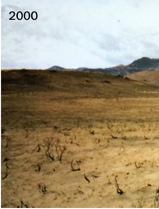
Figure 7. These photos display the same landscape, a portion of Cottonwood Ranch’s Bureau of Land Management grazing allotment. The image on the left was taken in 2000 after the 11,000-acre Camp Creek Fire. The image on the right was taken in 2015 and illustrates the successful recovery of several native grasses. (Source: Hottle, 2016.)
Want to monitor local landscapes? Using a cell phone with GPS makes photographing the landscape and sharing these images with others easy. Report information to the State Climate Office or via CoCoRaHS to help improve the quality of the data used to make management and policy decisions in Nevada.
Drought Impact Reporting
Identifying and documenting drought impacts is difficult. The Nevada State Climate Office under-stands that changes in weather and climate have wide-ranging impacts. Nevadans can communicate the severity of drought impacts directly with the Climate Office.
If drought is impacting you, please let the Climate Office know at UNR.
References
- Green, M. S. (2015). Nevada: a history of the Silver State. Las Vegas; Reno, University of Nevada Press.
- Hottle, Dan (2016, 9/21) Nevada’s ‘Shoesole’ Ranchers Grazing Cattle For Sustainable Results, Not For Federal Regulations. US Fish and Wildlife Service Pacific Southwest Region. FWS
- Ralph, F. M., and M. D. Dettinger. Storms, floods, and the science of atmospheric rivers. Eos 92.32 (2011): 265-266.
Resources
- What is Climatology? National Drought Mitigation Center (NDMC), the U.S. Department of Agriculture (USDA) and the National Oceanic and Atmospheric Administration (NOAA). The Drought Center
- U.S. Drought Monitor. National Drought Mitigation Center (NDMC), the U.S. Department of Agriculture (USDA) and the National Oceanic and Atmospheric Administration (NOAA).
- Cooperative Observer Program. National Weather Service (NWS). COOP
- El Niño and La Niña. National Oceanic and Atmospheric Administration. Climate
Published by:
Ormerod, Kerri Jean; McAfee, Stephanie, 2017, Nevada's Weather and Climate, Extension | Fact Sheet 17-04
An EEO/AA Institution. Copyright © 2026, University of Nevada Cooperative Extension.
A partnership of Nevada counties; University of Nevada, Reno; and the U.S. Department of Agriculture
