Introduction
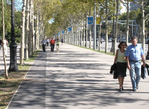
The physical structure (termed built environment) of communities that encourages physical activity has steadily declined. Residents must rely more on cars to run everyday errands, reducing their physical activity and impacting their health (Robert Wood Johnson Foundtion, 2007). Communities are now realizing the need to rethink how their built environments encourage physical activity and to build “Active Community Environments” to increase residents’ physical activity behavior (Washington State Department of Health, 2013). Rural residents show lower rates of physical activity than urban residents due to rural safety concerns and longer travel distances to physical activity facilities (Froster et. al, 2010). Working toward this aim, the Centers for Disease Control and Prevention (CDC) have established the Healthy Community Design Initative (CDC). The initiative emphasizes collaborations among public health, rural and urban design and community leaders with varying perspectives, to advocate built environment policy changes.
Even a small increase in daily physical activity may prevent weight gain (Morabia & Costanza, 2004). Studies show that people in neighborhoods with a mix of shops and businesses within easy walking distance have a 35 percent lower risk of obesity (Frank, Andersen & Schmidt, 2004), thereby reducing their risk for heart disease, diabetes and poor health status. Such neighborhoods increase incentives for walking by locating usual activities along interconnected networks of streets, sidewalks, paths and opportunities for physical activity. “For every dollar invested in building [bike/pedestrian] trails, nearly three dollars in medical cost savings may be achieved.” (Wang, et. al., 2005)
Physical Activity Status in Nevada
Unfortunately, most Nevada children and adults do not get enough physical activity. In 2009, most recent Nevada specific data, about 25 percent of Nevadan adolescents indicated they had achieved the recommended 60 minutes or more of physical activity per day in the previous week (CDC, 2012). Nevada is not included in 2011 data collection. In addition, adolescents indicated they failed to get the recommended muscle and bone strengthening activity of at least three days per week. In 2011, approximately one-half (53 percent) of adult Nevadans did not achieve the recommended 150 minutes of moderate-intensity aerobic activity per week, and only 30% participated in muscle strengthing exercises twice per week (CDC, 2011).
Geographic Information Systems (GIS) as a Tool to Assist in the Design of Active Community Environments
Geographic Information Systems (GIS) offers a means to evaluate how citizens interact within neighborhoods to foster healthy lifestyles (Ricketts, 2003). GIS can assess current neighborhood built environment factors such as roads, parks and sidewalks and resident characteristics such as physical activity level, age, and health status in an interactive and visual way. By using GIS, neighborhood strengths and weaknesses can be determined and potential strategies can be identified for recommended change. For example, the neighborhood walkability can be displayed visually, showing roads without safe crosswalks overlaid with the number of people living in the area who select an alternate route and method of transportation to their destination. Less commute time increases the likelihood of engaging in leisure time physical activity (Yang et. al, 2012). GIS can provide critical insight in understanding human behavior such as how do residents seek ways to overcome physical activity barriers. Incorporating this technical evaluation can assist in community planning.
Collaboration is essential in designing an Active Community Environment. GIS data can guide community leaders, planning commissioners, lawmakers, public health professionals and citizens in making well-informed decisions regarding community design and policies promoting physical activity. Toolkits and guides to create partnerships, such as the Active Community Environment Toolkit (Washington State Department of Health, 2013) exist to help foster partnerships.
Availability of Nevada GIS Data
Availability of Nevada GIS Data Over the past few years the number and breath of GIS databases have grown exponentially. Several federal agencies maintain websites containing free GIS data that provide information regarding Nevada:
Nevada GIS information is also available at:
Unfortunately, little or no GIS data may be available at the neighborhood- evel.
Alternate Tools for Neighborhood Evaluation
One way to obtain GIS data in remote Nevada areas at a neighborhood scale, and to promote community involvement is to ask residents to map neighborhood variables such as aesthetics of area, presence of parks, and location of crosswalks and to complete a rating checklist (Hoehner, et. al, 2007). Resident observational tools can also be used to track the use of existing physical activity opportunities (Kaczynski, Stanis & Beseny, 2012).
Summary
Active Community Environments seeks to increase a resident’s amount of physical activity, thus contributing to better health outcomes. GIS is a valuable tool in achieving this goal through mapping and examining potential interactions between built environments, citizen characteristics’ and health outcomes. In addition, GIS use has been enhanced with the expanded public availability of GIS databases. Through strong public health, legislative, urban designer, civic leaders and community resident partnerships, GIS can evaluate, design and build physical activity-oriented and healthier places.
References
- Centers for Disease Control and Prevention (2012). Youth Risk Behavior Surveillance – United States, 2011 Morbidity and Mortality Weekly Report, 61(4), 35-36.
- Centers for Disease Control and Prevention (CDC). Behavioral Risk Factor Surveillance System Survey Data. (2011) Atlanta, Georgia. U.S. Department of Health and Human Services, Centers for Disease Control and Prevention
- Foster, S.S., Goins, R.J. Hunter S.P., Bryant, L.L., Kruger, J., Pluto, D. (2010). Effects of the Built Environment on Physical Activity in Adults Living in Rural Settings. Am J Health Promot, 24(4), 267-83.
- Frank, L., Andersen, M., Schmidt, T. (2004). Obesity relationships with community design, physical activity and time spent in cars. American Journal of Preventive Medicine, 27, 87-96. Retrieved from: ALR.
- Hoehner, C., Ivy, A., Brennan-Ramirez, L., Handy, S., Brownson, R. (2007) Active Neighborhood Checklist: A User-Friendly and Reliable Tool for Assessing Activity Friendliness. American Journal of Health Promotion, 21(6), 534-537.
- Kaczynski, A.T., Stanis, S.A., Beseny, G.M. (2012 Development and testing of a community stakeholder park audit tool. American J Prev Med, Mar; 42(3), 242-9.
- Morabia, A., and Costanza, M. (2004). Does walking 15 minutes per day keep the obesity epidemic away? Simulation of the efficacy of a population-wide campaign. American Journal of Public Health, 94(3), 437-440.
- Ricketts, T.C. (2003). Geographic information systems and public health. Annu Rev Public Health, 24,1-6.
- Wang, G., Macera, C., Scudder-Soucie, B., Schmid, T., Pratt, M. Buchner, D. (2005). A cost-benefit analysis of physical activity using bike/pedestrian trails. Health Promotion Practice, 6(2),174-9.
- Washington State Department of Health, (modified 2013). Active Community Environment Toolkit Creating Environments that Encourage Walking, Biking, and Public Transit in Washington State Publication Number: 340-205 Centers for Disease Control and Prevention, Healthy Community DesignInitiative Retrieved from: CDC.
- Yang, W., Spears, K. E., Zhang, F., Wai, L., Himler, H. (2012) Evaluation of Personal and Built Environment Attributes to Physical Activity: A Multilevel Analysis on Multiple Population-Based Data Sources, J of Obesity, Article ID 548910.
- Multilevel Analysis on Multiple Population-Based Data Sources, J of Obesity, Article ID 548910.
Spears, K., Powell, P., and Yang, W.
2013,
How Geographic Information Systems Can Help Develop Active Community Environments,
Extension | University of Nevada, Reno, FS-13-24
