Fuel Management Terms for Homeowners
Defensible Space
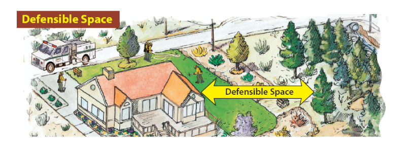
"Defensible space" is an area between a house and an oncoming wildfire where the vegetation has ben managed to reduce the wildfire threat and allow firefighters to safely defend the house.
Survivable Space
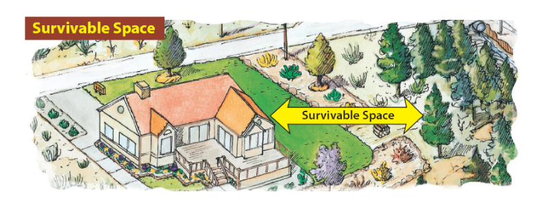
"Survivable space" is similar in concept to defensible space, except it emphasizes the house surviving a wildfire without significant firefighter or homeowner assistance.
Firebreak vs. Fuelbreak
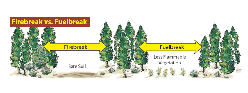
Some sources consider the terms firebreak and fuelbreak as synonymous, while other differentiate between the terms. For the later group, a firebreak is an opening or strip of land where vegetation is absent and bare soil is usually present, and it is effective in preventing the spread of wildfire. Firebreaks can be naturally occurring (e.g., rivers and rock outcrops) or manmade. A fuelbreak is a strip of land where flammable vegetation has been removed and less hazardous vegetation is retained.
Shaded Fuelbreak
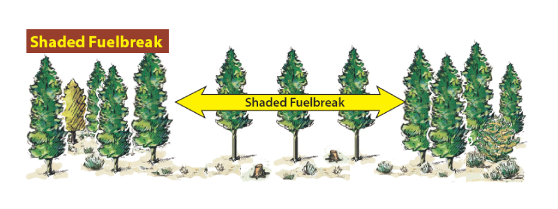
This is a type of fuelbreak in forested areas where the trees have been thinned, tree canopies have been raised through removal of lower branches, and the understory vegetation has been managed to reduce the fire threat.
Ladder Fuels and Continuity
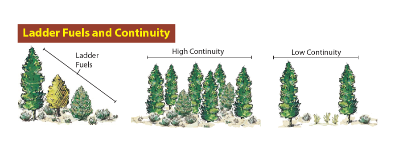
Vegetation that would allow a fire to ignite taller vegetation, such as tree branches, is referred to as "ladder fuel." "Continuity" refers to the uniformity and density of fuels. Plants that are growing close together with little open space between them have "high continuity" and are a fire hazard. Vegetation that is sparse and widely separated has "low continuity" and is less of a threat.
Greenstrips
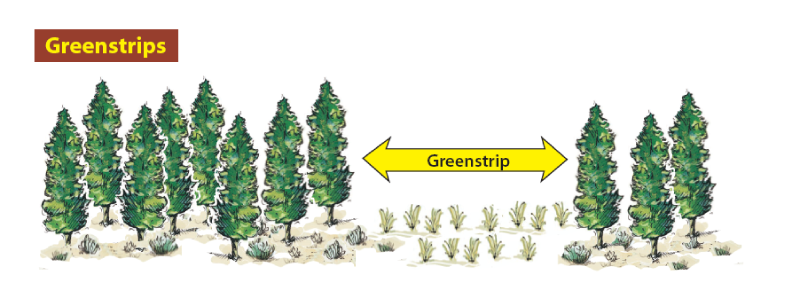
A "greenstrip" is a strip of land where fire-resistant vegetation has been planted to reduce the wildfire threat. Crested wheatgrass is often planted in Nevada greenstrips.
Smith, E.
2005,
Fuel Management Terms for Homeowners,
Extension | University of Nevada, Reno
Extension Associated Contacts
Fuel Management Terms for Homeowners
Defensible Space
"Defensible space" is an area between a house and an oncoming wildfire where the vegetation has ben managed to reduce the wildfire threat and allow firefighters to safely defend the house.
Survivable Space
"Survivable space" is similar in concept to defensible space, except it emphasizes the house surviving a wildfire without significant firefighter or homeowner assistance.
Firebreak vs. Fuelbreak
Some sources consider the terms firebreak and fuelbreak as synonymous, while other differentiate between the terms. For the later group, a firebreak is an opening or strip of land where vegetation is absent and bare soil is usually present, and it is effective in preventing the spread of wildfire. Firebreaks can be naturally occurring (e.g., rivers and rock outcrops) or manmade. A fuelbreak is a strip of land where flammable vegetation has been removed and less hazardous vegetation is retained.
Shaded Fuelbreak
This is a type of fuelbreak in forested areas where the trees have been thinned, tree canopies have been raised through removal of lower branches, and the understory vegetation has been managed to reduce the fire threat.
Ladder Fuels and Continuity
Vegetation that would allow a fire to ignite taller vegetation, such as tree branches, is referred to as "ladder fuel." "Continuity" refers to the uniformity and density of fuels. Plants that are growing close together with little open space between them have "high continuity" and are a fire hazard. Vegetation that is sparse and widely separated has "low continuity" and is less of a threat.
Greenstrips
A "greenstrip" is a strip of land where fire-resistant vegetation has been planted to reduce the wildfire threat. Crested wheatgrass is often planted in Nevada greenstrips.
Published by:
Smith, E., 2005, Fuel Management Terms for Homeowners, Extension | University of Nevada, Reno
An EEO/AA Institution. Copyright © 2026, University of Nevada Cooperative Extension.
A partnership of Nevada counties; University of Nevada, Reno; and the U.S. Department of Agriculture
